Menu

Show posts

This section allows you to view all posts made by this member. Note that you can only see posts made in areas you currently have access to.

Show posts Menu

Messages - Magellan

#16
Themes - Vector maps / Inaccurate svg rasterization
December 10, 2021, 12:06:34
Hi

I am replacing PNG to SVG graphics in one of the themes.
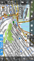
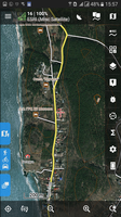
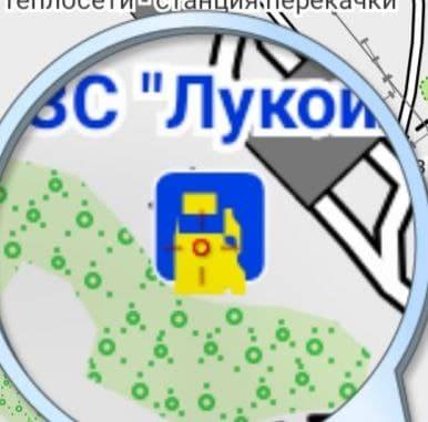
And I ran into the fact that Locus rasterizes some files inaccurately in the V3 version. For example, here is the petrol station icon in V3


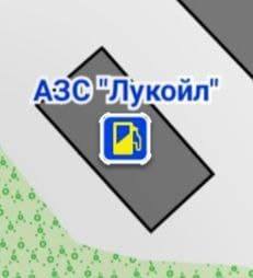
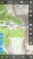
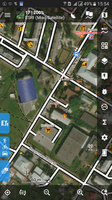
but in the same Locus, but for 4+ maps, the same SVG - everything is fine:


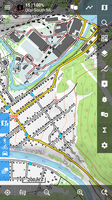
in the Cruiser is also normal

SVG code:
<svg width="28" height="28" version="1.1" viewBox="0 0 7.4083 7.4083" xmlns="http://www.w3.org/2000/svg">
<rect x=".26455" y=".2697" width="6.8792" height="6.8792" rx="1.0583" fill="#0042e8" stroke="#ffffff" stroke-width=".52917"/>
<rect x=".26455" y=".2697" width="6.8792" height="6.8792" rx="1.0583" fill="#0042e8"/>
<path d="m4.64884 2.544505 0.49355-0.0109v0.43681c0 0.2912 0.52914 0.5824 0.52914 0.8736v1.456c0 0.1456-0.14557 0.1456-0.14557 0.1456s-0.14563 0-0.14563-0.1456v-0.72801c0-0.1456-0.14557-0.2912-0.2912-0.2912-0.097049 0-0.44029 0.0109-0.44029 0.0109zm-2.654-0.94802h2.1046v1.3054h-2.1046zm-0.25813-0.50799c-0.16129 0-0.29117 0.12988-0.29117 0.29121v4.6592c0 0.1456 0.14555 0.2912 0.29117 0.2912h2.6209c0.1456 0 0.29123-0.1456 0.29123-0.2912v-1.456l0.29469-0.0109c0.14549-5e-3 0.1456 0.1456 0.1456 0.1456v0.58241c0 0.2912 0.14563 0.4368 0.43683 0.4368 0.29117 0 0.4368-0.1456 0.4368-0.4368v-1.6016c0-0.2912-0.52917-0.5824-0.52917-0.8736v-0.87361h-0.2912l-0.49355-0.28027v-0.2912c0-0.16133-0.12988-0.29121-0.29123-0.29121z" color="#000000" fill="#fcec00"/>
</svg>


Rule in theme V3:

<rule cat="tms_trans-priv" e="any" k="amenity" v="fuel">
<symbol priority="310" force-draw="1" id="s_trans-priv" src="file:/symbols/s_fuel.svg" symbol-width="12dp" />  <!-- был 2  symbol-height="16"  -->
<caption priority="250" symbol-id="s_trans-priv" cat="tms_land-names" k="name" dy="-12dp" font-style="bold" font-size="9dp" fill="#0036D9" stroke="#FFFFFF" stroke-width="2.0dp" />
</rule>


What can be done in this situation?

(changed sizes and padded, cleared the cache, no correct display....)
#17
OpenMaps


Simple modified theme.
Source here: https://openmaps.eu/mapsforgedownload

The resources are the same, but in the process of modification, smartphones with different DPI were used.

for V3 - OpenMaps LE.xml   (dpi=240.. 320)
for V4 - OpenMaps Mapsforge.xml (dpi=480 )

therefore there is a difference in line thickness, font sizes, overall readability, etc.

The legend is here: https://openmaps.eu/renderthemes/maplegend_EN.pdf

Screenshots


The menu also turned out different for V3 and V4
   
For example, in V3 (OpenMaps LE.xml) , Mary's path is removed, and instead of it - car parking.

The following objects, specific for both OAM and LM, were added:
cutline, grassland, barrier | natural = ditch | gully, safety_rope | ladder | rungs, man_made = adit | adit_disused, minor_line, type = communication ...
Сhanged cliff | earth_bank, embankmen  and many, many other little things that you can no longer remember...

This theme was with me on many trips (more than 2,000 km in the mountains), over the years, during which it was corrected, as needed. Therefore, I had to make it under V4 too ...(Thanks Felipe! Be happy, man, and I started your seed.)

No further plans to improve it, just share it with you :)
#18
Themes - Vector maps / Re: [Theme] VanLifeMapV4
January 22, 2021, 09:49:52
Maybe something like this display would be more successful?


For example, the following code:
<rule e="way" k="natural" v="*">

<!--  other natural -->

<rule e="way" k="*" v="cliff|earth_bank" zoom-min="14"> 
<line stroke="#606060" stroke-width="1.20" dy="0.36" stroke-dasharray="0.8,5" stroke-linecap="butt" />
<line stroke="#606060" stroke-width="0.42" stroke-linecap="butt" />
<rule e="way" k="*" v="*" zoom-min="15"> <!--  rule for k="name" -->
<!--  . . .  -->
</rule>
</rule>

<!--  other natural -->

</rule>


#19
Themes - Vector maps / Re: [Theme] VanLifeMapV4
January 22, 2021, 09:35:27
I live in a mountainous area.
Of course, this is a matter of taste, but I do not think the display of natural=cliff using file: res/ls_cliff. svg is successful. It looks sloppy. The main drawback with this display is the fuzzy cliff line.
(https://www.openstreetmap.org/#map=16/55.3322/59.7002)

#20
Themes - Vector maps / Re: [Theme] VanLifeMapV4
January 20, 2021, 15:42:07
Martin, I tested your theme a bit and find it very nice and balanced. Thanks for your hard work!
Found this:
Pay attention to intersections and crossroads.
It's located here:
https://www.openstreetmap.org/#map=17/55.35216/59.41111
It seems to me that the sequence of specifying different types of roads is wrong here. (casings / cores for residential, tertiary, service, etc.)
Or is it intended?
#21
John, with all due respect, which tags specifically mark these very sealed roads so that you can speak objectively. Or, a collection of tags?
#22
Andrew Heard!
Sorry, but what kind of tag in the OSM marks these sealed roads?
#23
Hello, Jochen

For this, the maps must contain within themselves such data of contour lines (10 m). OAM, lomaps contain only contour lines of 20 m.

The way out of this situation is to completely make such maps or a map containing only the contours of the heights, the required frequency and overlay it with the corresponding theme.

But, again - do it yourself.

Well, or ask map manufacturers to make contour lines of heights more often.
#24
Updated version 2.1 in the first post, please update. Unpack with overwrite.
Improved: streams, rivers, embankments, railways and more. Added traffic lights.  (84 changes)
#25
Quote from: Andrew Heard on June 17, 2019, 23:46:24I can't see any link to the V4 theme?
You must log in to this forum to see the attached files in the posts.
#26
Yes, this theme intentionally does not contain trails, paths and routes. But for highway=path|footpath there are differences in coloring, according to sac_scale. "Bad" highway=track (tracktype=grade 3|grade 4|grade 5) is marked with a red dotted line.
#27
Thanks for the tip, guys!
Long could not understand, where I have this full-screen advertisements climbs...

I mostly use Mobile Topographer Free:
https://play.google.com/store/apps/details?id=gr.stasta.mobiletopographer&hl=en

With the Locus on friendly terms!
(via the right panel to call third-party applications)
#28
Tiramisù as OpenTopoMap

   
for the topography, and exploration on the maps

only for V4 maps!

For V3 (lomaps and other)  TOTM 1.9.2 - > https://forum.locusmap.eu/index.php?topic=6027.0

in the future it will be slightly improved:

  • all water except springs (rivers, streams, lakes, canals, etc.)
  • all railway and tram
  • all labels
  • setting priorities
  • streets, driveways and younger roads in the direction of greater elegance (at the moment - too thick)
on my smartphone 282 ppi, 320 dpi

It also works well on Oruxmap, Cruiser, and most likely in other mapsforge-compatible programs
(tested in Oruxmaps 7.4.22, Cruiser 1.7)


Map: ESRI satellite;  Overlay 85%: OAM Ural ML;  Layer "Terrain" in the theme is OFF


Waiting for comments and constructive criticism.
#29
Thanks for the hint about the problem tags in the theme for V4 on your site.
#30
Themes - Vector maps / Re: [Theme] TOTM
April 20, 2019, 22:19:31
I understand, from the discussion below, the developer refused to support locus-extended = "1", scale-line-dy-by-zoom = "1" and other features.
Those. need to rewrite the whole theme TOTM. I don't know how to do it yet. If there are intelligible tips on redoing, then I will definitely do it.