Menu

Show posts

This section allows you to view all posts made by this member. Note that you can only see posts made in areas you currently have access to.

Show posts Menu

Topics - Magellan

#1
My thanks to the author of this wonderful rendertheme - Maki!

After the post of the author of Tiramisu EOL, this theme has been corrected and developed.


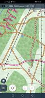
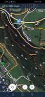
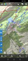
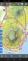
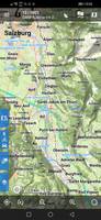
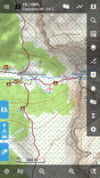
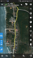
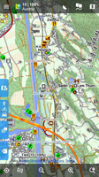
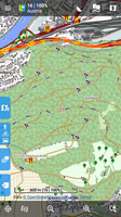
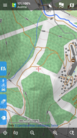
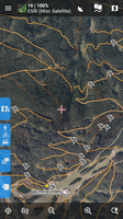
The rendertheme has now been corrected with the latest changes in routes (hiking, MTB, cycling) in OAM with an update date of January 2022e.

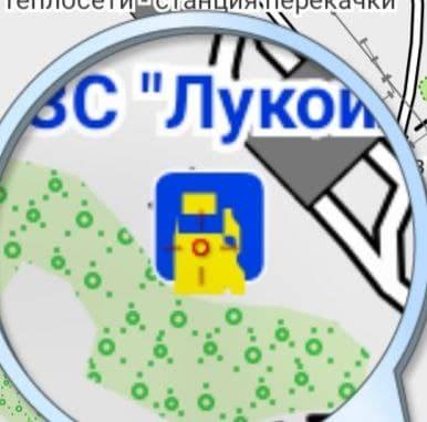
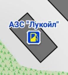
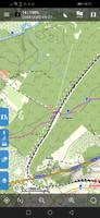
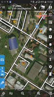
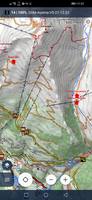
Added new POIs, Bike-Park scale IMBA tracks, trails and lots of little things.

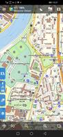
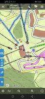
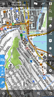
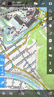
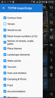
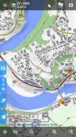
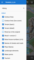
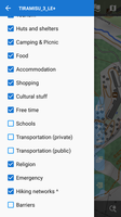
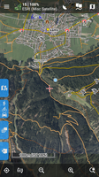
Because the theme is designed for a distant outdoor, all icons are always displayed as soon as they appear in the map data and in urban conditions can lead to oversaturation of the map and mutual overlap of icons. Therefore, use layers in the theme menu more actively and turn off unnecessary ones. Still, a topic for areas where POIs are scattered more widely.

From Tobias Kuen's Elevate family of themes, this theme is the closest to the Elements theme.

Links:
https://tartamillo.wordpress.com/tiramisu/
https://tartamillo.wordpress.com/2022/01/03/tiramisu-eol/
https://www.openandromaps.org/en/home_en
https://github.com/IgorMagellan/Tiramisu
#2
Themes - Vector maps / Inaccurate svg rasterization
December 10, 2021, 12:06:34
Hi

I am replacing PNG to SVG graphics in one of the themes.
And I ran into the fact that Locus rasterizes some files inaccurately in the V3 version. For example, here is the petrol station icon in V3


but in the same Locus, but for 4+ maps, the same SVG - everything is fine:


in the Cruiser is also normal

SVG code:
<svg width="28" height="28" version="1.1" viewBox="0 0 7.4083 7.4083" xmlns="http://www.w3.org/2000/svg">
<rect x=".26455" y=".2697" width="6.8792" height="6.8792" rx="1.0583" fill="#0042e8" stroke="#ffffff" stroke-width=".52917"/>
<rect x=".26455" y=".2697" width="6.8792" height="6.8792" rx="1.0583" fill="#0042e8"/>
<path d="m4.64884 2.544505 0.49355-0.0109v0.43681c0 0.2912 0.52914 0.5824 0.52914 0.8736v1.456c0 0.1456-0.14557 0.1456-0.14557 0.1456s-0.14563 0-0.14563-0.1456v-0.72801c0-0.1456-0.14557-0.2912-0.2912-0.2912-0.097049 0-0.44029 0.0109-0.44029 0.0109zm-2.654-0.94802h2.1046v1.3054h-2.1046zm-0.25813-0.50799c-0.16129 0-0.29117 0.12988-0.29117 0.29121v4.6592c0 0.1456 0.14555 0.2912 0.29117 0.2912h2.6209c0.1456 0 0.29123-0.1456 0.29123-0.2912v-1.456l0.29469-0.0109c0.14549-5e-3 0.1456 0.1456 0.1456 0.1456v0.58241c0 0.2912 0.14563 0.4368 0.43683 0.4368 0.29117 0 0.4368-0.1456 0.4368-0.4368v-1.6016c0-0.2912-0.52917-0.5824-0.52917-0.8736v-0.87361h-0.2912l-0.49355-0.28027v-0.2912c0-0.16133-0.12988-0.29121-0.29123-0.29121z" color="#000000" fill="#fcec00"/>
</svg>


Rule in theme V3:

<rule cat="tms_trans-priv" e="any" k="amenity" v="fuel">
<symbol priority="310" force-draw="1" id="s_trans-priv" src="file:/symbols/s_fuel.svg" symbol-width="12dp" />  <!-- был 2  symbol-height="16"  -->
<caption priority="250" symbol-id="s_trans-priv" cat="tms_land-names" k="name" dy="-12dp" font-style="bold" font-size="9dp" fill="#0036D9" stroke="#FFFFFF" stroke-width="2.0dp" />
</rule>


What can be done in this situation?

(changed sizes and padded, cleared the cache, no correct display....)
#3
OpenMaps


Simple modified theme.
Source here: https://openmaps.eu/mapsforgedownload

The resources are the same, but in the process of modification, smartphones with different DPI were used.

for V3 - OpenMaps LE.xml   (dpi=240.. 320)
for V4 - OpenMaps Mapsforge.xml (dpi=480 )

therefore there is a difference in line thickness, font sizes, overall readability, etc.

The legend is here: https://openmaps.eu/renderthemes/maplegend_EN.pdf

Screenshots


The menu also turned out different for V3 and V4
   
For example, in V3 (OpenMaps LE.xml) , Mary's path is removed, and instead of it - car parking.

The following objects, specific for both OAM and LM, were added:
cutline, grassland, barrier | natural = ditch | gully, safety_rope | ladder | rungs, man_made = adit | adit_disused, minor_line, type = communication ...
Сhanged cliff | earth_bank, embankmen  and many, many other little things that you can no longer remember...

This theme was with me on many trips (more than 2,000 km in the mountains), over the years, during which it was corrected, as needed. Therefore, I had to make it under V4 too ...(Thanks Felipe! Be happy, man, and I started your seed.)

No further plans to improve it, just share it with you :)
#4
Tiramisù as OpenTopoMap

   
for the topography, and exploration on the maps

only for V4 maps!

For V3 (lomaps and other)  TOTM 1.9.2 - > https://forum.locusmap.eu/index.php?topic=6027.0

in the future it will be slightly improved:

  • all water except springs (rivers, streams, lakes, canals, etc.)
  • all railway and tram
  • all labels
  • setting priorities
  • streets, driveways and younger roads in the direction of greater elegance (at the moment - too thick)
on my smartphone 282 ppi, 320 dpi

It also works well on Oruxmap, Cruiser, and most likely in other mapsforge-compatible programs
(tested in Oruxmaps 7.4.22, Cruiser 1.7)


Map: ESRI satellite;  Overlay 85%: OAM Ural ML;  Layer "Terrain" in the theme is OFF


Waiting for comments and constructive criticism.
#5
Themes - Vector maps / [Theme] TOTM (V3)
January 29, 2018, 16:09:50
Tiramisù as OpenTopoMap

No routes, only topography, better larger zoom.

for V3 maps

On the OAM maps, there are intermittent streams, embankment, ridges, cutlines, etc....

It is recommended to use with the "Hill shading" map is ON - that the similarity is maximized.

There was no purpose to do an exact copy, but to use the best features.


OpenTopoMap -> https://www.opentopomap.org

Update: ver1.8 (15/02/2018)
- again redrawn the forest, with transparency. Now it is correctly mixed with other fills and objects.
- added or changed: mountain_pass | saddle, natural = stone, tower: communication, volcano, turning_circle, man_made = adit | adit_disused, wells water_well, waterfall, summit: *, fixed reservoir | basin, redrawed bare_rock, completed the color of main roads
- the mapping of the mountainous terrain has been reworked,
- added a layer of "Winter routes", the display - slightly adjusted copy-paste from the built-in theme "Skiing"
adjusted visibility on different zoom levels amenity|waterway / natural = drinking_water|water_point|spring|fountain

Update: ver1.9.2 (15/01/2019)
landuse kindergarten, school...
contour path text rotate_up=false (always uphill")
selection of landuse hospital, residential, adjustment of overlays
slightly thicker contour lines
removed signatures on fence | wall | city_wall
added water sources zoom-min= " 13"
added barrier=turnstile (OAM), name=neighbourhood|quarter
and other things...
#6
Source: Tiramisù 3.0.2 for Oruxmaps and MapsForge compatible applications
http://tartamillo.wordpress.com


**********************************************************************
*  Great thanks Maki for such a Grand work and a sense of beauty!  *
**********************************************************************


Now able to work in Locus. Some layers have been added. This theme is only for maps version 3. (lomaps and other V3)
Redone the "scrub", now this is a clarified version of the forest from version 2.
The "wood" is now correctly displayed taking into account the type of foliage and has a different shade, for example, coniferous - darker. Increased object signatures, house numbers, regrouped layers
and many many other small things ....

[ 
Satellite map  + overlay Lomaps with the included layers of tourism and huts only ... everything else is off

Updated to 3LE+5 (12/02/2018):
- slightly increased the visibility of the trails
- buildings names in Place Names
- underground waterways
- intermittent streams and rivers (OAM only)
- embankment's  (OAM)
- and the little things are different
#7
Cursors / Icons / Voices / [CURSORS] Motor boat
September 19, 2017, 06:41:46
The cursor navigation is a motor boat.
most screens (except for the smallest): mdpi, hdpi, xhdpi

for light maps


for dark maps


of course, used images from other sets too  :)
#8
Tools / Problem GPSies Live Tracking
January 06, 2016, 19:21:37
Quote
What's the problem with GPsies?
When setting Locus, exactly as instructed http://www.locusmap.eu/locus-live-tracking-with-gpsies/
(my screenshots below)
   

enabled tracking locus and available network WiFi (or mobile data)
on the site gpsies page http://www.gpsies.com/liveTracking.do?showAll=true
my nickname does not appear, even though the notifications panel from tracking Locus shows that the sending of the data is successful: 5/0 - GPsies

If you turn their own program http://www.gpsies.com/page.do?page=android that I appear

I do not understand where is the dog fumbled ...