Menu

Show posts

This section allows you to view all posts made by this member. Note that you can only see posts made in areas you currently have access to.

Show posts Menu

Messages - bezel

#76
menion, I really, really appreciate your work, your fast support and the whole work your team is doing for Locus Pro !
I love the app so much and use it so many times I can not imagine how it would be without this app.

But your idea of the subscription model disappoints me a lot - I payed for LocusPro and pay for the Lomaps; but I can not imagine to pay more than 10€ a year for using the new version.
For sure you have to be paid for your work, but so many people pay for the Pro version (and maybe aswell for the LoMaps).
There are so many travellers on the road who do not have so much money - and imagine the new modell would cost 1,50/months (18Euro/year) - already in 5 years you would have to pay 90 Euros...!!

It would be great to have further (real) updates aswell for the "old" Pro version - and the new V4-version maybe with an one-off payment of lets say 50 Euro or so - but then for lifetime usage!

Otherways it would be just not affordable for a lot of people - and therefore some will use other apps.
I really hope this abo-model is being rethought!

Best wishes, bezel

#77
Hallo!

bevor ich mir die neuen multilingualen v4-openandromaps runterlade:
funktioniert hier zwischenzeitlich mit LocusPro der automatische Kartenwechsel?

Ich dank' Euch für Eure Hilfe! Grüße!
#78
Wenn ich im dashboard die Anzeige eines Höhenprofils eingerichtet habe:

wie kann man dieses so einrichten, dass das Höhenprofil eines ganzen tracks, also auch für eine längere Strecke als 20km, angezeigt wird?

Vielen Dank und Grüße!
#79
Well - I tried it now several times with that setting, great, no problems anymore!
Thank you!
(...strange - before I didn't change anything, "zoom-function" seemed to be enabled with an update)
#80
Hallo sunshineh!

Gelegentlich zum Wandern nehme ich das HiLo-Wandertheme in Kombination mit den Openandromaps.
Gefällt mir recht gut. Vielleicht ist das ja auch was für Dich.
Infos dazu findest Du hier -> http://forum.locusmap.eu/index.php?topic=4982.msg41086#msg41086

Grüße!
#81
Quote from: john_percy on December 22, 2018, 13:36:35
...It's now found in Settings > Controlling > Map screen > Zoom according to speed
Thank you very, very much! (I didn't find the Settings for this Auto-Zoom...)
Hope it works now again.
#82
Hello!
During my last cycle-rides I discovered that the displayed map zooms out automatically without doing anything. Is there any I have to do? Some wrong settings maybe?
I never had this problem before...

just to imagine, see screenshots:
.
(yellow circle shows actual position)

GPS is on, display/ position set to be in the middle. This "Zoom out" happens when moving.

Thank you very much for your help!
#83
I think it is for cyclists (road/gravel/randonneur/mtb) very, very helpful to have for "all" slopes different colours.
It makes a big difference for a cyclist (but asewell for  hikers e.g.) if you have parts of a track with f.e. 4% then 10% or 14%!

It is quite good right now - after a couple of rides in the mountains I recognized, that
green stands for around 0-2%,
light green - 2-4%,
yellow - around 4-7%,
orange - 7-9%,
red - 9-12%,
dar red - above 12% .

Quote from: freischneider on December 09, 2018, 10:49:06
It would be nice if you could adjust:
Gradient 10-15% orange, 15-30% red and everything else in standard track color.
...
- you can set it manually just for the maximal slopes.

Not all are MTB-Cyclists - there are aswell the 'normal' Cyclists (s.a.), but aswell for hiking and trekking it is very important to know (all!) the slopes of a track and would be very helpful!

Best wishes!
#84
Hello menion,
thanks for your reply - I always aprecciate your help!
Concerning slope/elevetaion diagramms I thought you are in contact with the developers of LocusPro so I hoped you might help me or push this theme forward.
I know there is aswell a "wishlist" (locusforum), but I do not see that this really works and that the developers of LocusPro have a look at it.

I really hope that the slope thing will be realised and that we do not have to wait too long... I know a lot of trekkers, hikers and cyclists who are eager to get this feature.

Thank you anyway!
#85
Das heisst, die app an sich liegt aber weiterhin auf dem Gerätespeicher?
(nur Karten etc. sind auf der SD-Karte ausgelagert?)
#86
Hallo!
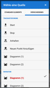
Bei erstelltem individuellen Dashboard kann man sich bei Navigation oder Zielführung entlang eines dargestellten Tracks ein Diagramm mit dem Höhenprofil der Strecke darstellen lassen (mit Angabe der aktuellen Position):


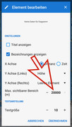
Allerdings wird das Profil nur immer maximal für eine Strecke von 20 Kilometer angezeigt. Bei der Erstellung des Dashboards (Element "Diagramm" einfügen/ siehe screenshot) kann man bei der Festlegung/ Bearbeitung der Parameter für das Höhenprofil leider nur eine Strecke von maximal 20000 Meter eingeben (max. sichtbarer Bereich/ siehe screenshot).


Ist es irgendwie möglich, das Höhenprofil auch für längere Strecken (über 20 Km!) im Gesamten hier anzeigen zu lassen?
Ich denke gerade an Strecken bis zu vielleicht 150 Km - da ist es ganz hilfreich, deren Höhenprofil (wenn dann auch etwas gestaucht) über den ganzen Bereich sehen zu können.

Hat jemand eine Idee oder sieht eine Möglichkeit, diese maximale Begrenzung (20Km) zu ändern?
Vielen, vielen Dank! Grüße
#87
Quote from: menion on November 30, 2018, 10:16:42
It is not possible to select exact values.
Anyway, a "pencil" icon next to "slope" option allows defining automatic or manual coloring. Automatic spread color between minimal and maximal slope values found in track. In case of manual, you may define these limits.
Menion, did you find a solution for the "problem" I mentioned above?

see my reply #4 (http://forum.locusmap.eu/index.php?topic=6400.msg53427#msg53427)
#88
Thanks, menion, for your quick reply.
It is a bit sad that there is no reference-% (in case of selecting "slope" as one of the options) for each colour!


Quote from: menion on November 30, 2018, 10:16:42
Automatic spread color between minimal and maximal slope values found in track.
I like the automatic mode so there I can see all colours/slopes - it would be great to get the reference value for the colours - an option for future updates or the locus-handbook.
I know - it is not possible to get the exact values - but it would be very helpful to know, if the slope is for example between 4-7% or between 8-11% or over 12% ... ((especially for cycling or hiking) ).


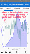
And the other "solution"/ way in Locus (graphic diagram with distance/height and slope) is very, very complicated and there is aswell no sign, where the selected point of the track is...


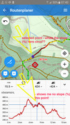
And within the routplanner - you can display the hight display (in this case very good WITH (!) the selected point - see "blue cross"/diagram and blue ring(map) - but still I miss there the displaying of the slope-data!


We miss this feature in Locus so much (by the way: Osmand did find  a solution to show the slope-% at each selected point)...

Please, it is a feature which is really, really helpful for all actives out there:
- to know what the slope-colours in a track refer to (circa % values)
- AND: to show at a selected point within a track the slope at that point!


Would be absolutely perfect if an update could manage this!
Thank you very much!
#89
Hi menion!
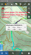
But with the line style I do select "slope" to be coloured - see the screenshot.

It would be absolutely great if the colors would refer the to a value, f.e. green  0%, yellow 4-6%, orange 6-8%,red 9-12%, dark red > 12%.
Or can I do this by myself?
#90
Hello!
I just discovered that there is now a possibility to show the slope of a created track with a different coloured track line:


But:
for what of gradient in percent do the colours stand for (red,orange,yellow,turquoise,blue and so on)?

Thank you very much for your help!