Menu

Show posts

This section allows you to view all posts made by this member. Note that you can only see posts made in areas you currently have access to.

Show posts Menu

Messages - erfi

#1
So let's move a little ;)

New Alpha version 3.44.1.2 for testing.

Three major changes:

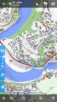
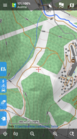
- I'm trying to unite work with points. So in this version is introduced new screen visible over the map and also everywhere in the app, that display detail of points. It should be fully working for all points except geocaches (here is currently an option to display old screen). The same system will be created for tracks, once we all will be satisfied with points :).

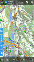
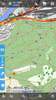
- Route planner: a new itinerary that displays a list of all shaping/via points with the option to reorder. Optionally in the RP settings is an option to enable chart for segments ;)

- Route planner: when using online GraphHopper, you now get an alternative route (if GH server think it exists). There is missing some more simple way to compare both routes, anyway, it's already well usable.

Feedback is of course welcome.

Version for download here
The following users thanked this post: erfi
#2
Ich habe Version BRouter 1.6.0 released:

http://brouter.de/brouter/revisions.html

wie immer erstmal nur als Distribution-Zip, erst im nächsten Patch in 2-3 Wochen dann auf Google-Play.

Wichtigste neue Feutures aus Locus-Sicht sind der Delta-Update der RD5-Dateien über den Download-Manager.

Und ein Bugfix bzgl. der Zeitprognosen in Locus ( siehe https://forum.locusmap.eu/index.php?topic=6765.0 )

wie immer vielen Dank für Tests und Feedback,

Gruss, Arndt
The following users thanked this post: erfi
#3
Oki, understand. No more comments related to this button needed. I'll create a working updated version to the next app version.

Theme? Please specify, not sure I understand.
The following users thanked this post: erfi
#4
[usw]
The following users thanked this post: erfi
#5
@slarti76
oki, I'm really glad to read this about "magnify" system.
About world map : good point, I'll fix it.

@john_percy
I'm not sure how to quickly fix it, but I add it to my list of smaller tasks related to improving of MF4 maps, thanks

@erfi
I was quite sure that it is fixed, but not on 100%, that's why I published Beta first. Thanks, I'll do more precise tests tomorrow.
The following users thanked this post: erfi
#6
As John already mentioned, hopefully, final new version 3.38.3 is out.

As I wrote on help desk (copy content here):
If you still won't be satisfied with how maps look like or behave in latest 3.38.3 version, here are a few tips:

  • automatic scaling: may be disabled in Settings > Maps > Advanced features > Optimized raster map resolution
  • slower zooming: check automatic loading in Settings > Maps > Offline maps or alternatively you may try to disable some map animations in Settings > expert settings > Smooth interface
  • incorrect display of 512x512px online maps: 512x512px tiles with same indexes (x, y) as for 256x256px does not make sense. Previously it worked more like an accident then an intent. Do make it work correctly, it is needed to use the method I described here.

Thanks for your help here and also big thanks to a few quick translators!
The following users thanked this post: erfi
#7
@erfi
thanks, you are correct. "Walking" was dependent on speed, but "Hiking" no. It was hardcoded to a single value per km. I've improved it and based on information I've found, changes are: "hiking" will use same values for computing of energy consumption like "walking" + 15%, which should be equal to carry 5kg backpack.

@Žajdlík Josef
hmm. Even with Czech description, I do not exactly understand where is the problem. Should be possible to create a short video of this problem? Thank you!
The following users thanked this post: erfi
#8
Other features / Re: Update of map core (2019)
April 06, 2019, 12:04:11
Hi guys,
one month delay ... not too bad I believe.

So who is brave enough to try the new special Alpha version? :)

How to:
Download 3.37.2.4 Map-alpha: https://asamm.myqnapcloud.com/share.cgi?ssid=04Wcqtt
Download 3.37.2.6 Map-alpha: https://asamm.myqnapcloud.com/share.cgi?ssid=0H4qEQX
Download 3.37.2.7 Map-alpha: https://asamm.myqnapcloud.com/share.cgi?ssid=0qcpBbS

Version is based on 3.37.2 + latest fixes + months of work on new "map core".

What to test:
Best: use as you usually do with the regular version.

I mainly try to achieve:
- better support for MapsForge V4 maps
- the good old Map manager that looks exactly the same as in current public version (it use different map system on background)
- improved suggested maps in "Quick map switch"
- better display of raster maps on devices with higher DPI
- correct work of overlays
The following users thanked this post: erfi
#9
Other features / Re: MapsForge maps V4/V5
January 03, 2019, 21:52:13
@Tobias
excellent description I needed, thanks :).

About themes: Currently, all V3 maps use Locus-MapsForge rendering system, V4+ maps use than MapsForge 0.10.0. So what I may do: allow all V3 and higher themes for V4+ maps oki? I'll look at it.

@freischneider
the mentioned topic is more feature request than some issue in V4 support. Sorry, this does not belong here and sorry second time: this will have to wait a little more.

---

Oki, so first post updated and list sorted by priorities as I feel it. Seems all should be doable. The major problem will be auto-loading system, but ... maybe not so big.

As I wrote on few places, currently I work on some bigger changes in how app work with maps, so expect during February some highly unstable version for testing, hopefully with some changes from this list :).
The following users thanked this post: erfi
#10
Other features / Re: MapsForge maps V4/V5
January 03, 2019, 21:02:14
Quote from: menion on January 03, 2019, 16:50:47
"Device screen scaling": I already read the post from Tobias, but I'm not too clever from this. What is the main issue he tries to describe except lack of interest in compatibility?
That post was more my tiredness of only limited support of new mapsforge features in various apps (not just Locus, but this was the app John came up with) which limit app-independent development as we do at OpenAndroMaps. In an older discussion I got the impression that LoMaps have a bigger priority than compatibility, but this new thread let's me hope for a change :-)

But as far as device screen scaling is concerned - as a cross-app-theme-developer this is the most important issue. It was introduced with mapsforge 0.4 in 2014, at first I was a bit sceptical but with very high ppi nowadays it's a must for good rendering, as far as I'm concerned.

Here's a description of the problem I posted in a different forum:
Quote
Mapsforge maps are meant to be scaled to screen density of the device, so that a map at 160ppi looks exactly the same as with 480ppi. To do that, not only symbols and line width are scaled, but also map tile size. So if you have a map tile size of 256px at 160ppi, you get 768px at 480ppi.
Locus uses a mod of a very old mapsforge version with no scaled tiles. So with modern devices with very high pixel density, you still get 256px like for devices years ago. The only thing that is scaled is line width and symbols. But as these grow larger (3x as large at 480ppi), the space on a 256px map tile gets more crowded, and less can be displayed. So when looking at the same zoom level, less and coarse information is shown.

Here are some comparison of a densely mapped are at zoom level 17:


At first, it looks as if Locus shows more - but this isn't the case, as the area is only larger as the tile sizes are smaller. The same area can achieved by OruxMaps by using the zoom button.

Now here you can see what details are available if tile size is adjusted:

In Locus, streets are rendered much too fat, so they overlap and swallow too much space. Only a few symbols are displayed, as most are eliminated because of too little space.

So the scaling policy of OruxMaps is true to how the maps are meant to be displayed and can be scaled to every pixel density without loss of details. The only disadvantage is that with larger tile size direct comparison to online maps with old 256px tile size is not possible (although there are more HD maps coming with larger tile size as it's necessary to keep the legible on high density devices).

On my to-do-list for the Locus version right now is the idea of moving all zoom-appears 1-2 levels as this is the only possibility right now to get it a bit better, but with other disadvantages.

Other issues:
- Folder structure for themes: only one theme xml per folder is allowed, and folder are also needed. Any other app with theme support allows xml files in base folder and graphics whereever the xml points to. So a special Locus format is always necessary. I get the one folder, one theme policy, but why not two or more xml files?
- Forced connection of V4 maps with V4 themes - it should be possible to use V3 maps with V4/V5 themes, or V3 maps and V3 standard mapsforge themes etc. Maybe use standard-mapsforge for all themes, whatever version, and locus-mapsforge-fork for those themes with locus-extended="1" in the rendertheme tag? That would solve the issues of the two posts above.

Best regards,
Tobias
The following users thanked this post: erfi
#11
Weird, just today morning (GMT+1) I've published new 3.33.1 version


But if I see correctly, it is still not available for download :/. Most probably some issue on the Google server. So just for your information ... the version is out and the issue is not on our side. Thanks.

@tapio
I thought it will be this issue ;).
The following users thanked this post: erfi
#12
I published locus action files to simplify routing data installing and updating — https://graphhopper.develar.org As for openandromaps, now you can simply click "Locus" link to install or update.
The following users thanked this post: erfi
#13
@Taras_D:
Fixed:
- highway=steps
- icons of the ladder, safety rope, ... now included in the "Tourism"

inside zip only xml, unpack with replacement


prefer to consider the path on the map off the fills, vegetation, contours of heights, and currently unneeded items
The following users thanked this post: erfi
#14
Source: Tiramisù 3.0.2 for Oruxmaps and MapsForge compatible applications
http://tartamillo.wordpress.com


**********************************************************************
*  Great thanks Maki for such a Grand work and a sense of beauty!  *
**********************************************************************


Now able to work in Locus. Some layers have been added. This theme is only for maps version 3. (lomaps and other V3)
Redone the "scrub", now this is a clarified version of the forest from version 2.
The "wood" is now correctly displayed taking into account the type of foliage and has a different shade, for example, coniferous - darker. Increased object signatures, house numbers, regrouped layers
and many many other small things ....

[ 
Satellite map  + overlay Lomaps with the included layers of tourism and huts only ... everything else is off

Updated to 3LE+5 (12/02/2018):
- slightly increased the visibility of the trails
- buildings names in Place Names
- underground waterways
- intermittent streams and rivers (OAM only)
- embankment's  (OAM)
- and the little things are different
The following users thanked this post: erfi
#15
Oki, thanks Michael. I'm surprised, there is any difference as I expected, results will be exactly same. I'll check it ...
The following users thanked this post: erfi