Menu

Show posts

This section allows you to view all posts made by this member. Note that you can only see posts made in areas you currently have access to.

Show posts Menu

Messages - lor74cas

#316
Quote from: tapio on August 06, 2018, 16:15:41
Quote from: menion on August 06, 2018, 09:18:45
@tapio
setup of "climbing/descending/flat speeds" is overkill
OK! Hey, Locus already does calculate decent ETAs internally for the temporary track... and also offers it in route planner (Menu -> Travel time) - There is "Bergwandern (mountain hiking)" which would be more appropriate for me for display in the bottom bar.

BTW as you probably know, Germany has a norm for this (DIN 33466):

Up: <u> meters
Down: <d> meters
Horizontal: <h> meters

Conservative assumption - the hiker walks per hour:
300m up
500m down
4km horizontal

Calculation:
a = u/300 + d/500
b = h/4
c = greater value of a and b
d = smaller value of a and b

Walking time: (0.5*c + d) hours


Interesting algorithm, I tried to insert my current trailrunning data and return a satisfactory ETA. Maybe the fatigue factor is missing, as the number of kilometers increases or the difference in height takes over the fatigue that makes slowing down, while the proposed formula is linear, the reality is a curve.
Obviously you have to compare similar data to get reliable results, you can not enter a time on 100 meters to look for time in the marathon.
However, it has a very good approximation to reality, thanks.
#317
Quote from: menion on August 06, 2018, 09:18:45
@lor74cas
battery saving mode is always ... "wrong" for GPS usage
Anyway I'll always suprised that my overcomplicated altitude system return quite good elevation values. Nice :)
I think your system of high complexity is used by the sapcex project, you have to try to ask them for money or a tesla in exchange for your code. ;)
I think the altitude manager needs some simplification once we find the way we have the best results.
We have these use cases:
A) no srtm - no baro> ok user do you want to download the srtm data to improve the altitude data? Yes (B) - No ok good luck I hope you are running by the sea, do not bother me for inaccurate elevation data :)

B) srtm - no baro> altitude assisted by srtm by default (I do not know which filter is the best solution)

C) no srtm - baro> ok user do you want to download the srtm data to improve the altitude data? Yes now (D) - No ok I hope you are by the sea, where you can calibrate your baro at 0 mt or do not bother me for inaccurate elevation data :)

D) srtm - baro> srtm and active baro in car with light filter

Any other configuration in an advanced menu (manual offset, geoid, nmea, calibration ...), is just my opinion, but emerges from the face of the frightened users I saw while watching the altitude manager (wife, friends, colleagues)

#318
Quote from: Andrew Heard on August 06, 2018, 02:09:00
Quote from: lor74cas on August 05, 2018, 21:44:36
Not a bug report just for information about power saving mode of my device.
Today I tested the battery saving mode on the a5 2017 Samsung
@lor74cas - thanks for report - I have just bought this phone so am hoping no power saving problems with Locus.
I note has inbuilt barometer - do you find the ascent measurement more accurate than a phone without inbuilt barometer?
I use light filter in combination with automatic gps calibration with good results. I also use hgt files with 1 arc accuracy.

Compared to the old s5 mini it's really more accurate, but elevation seem to not be exact science: every device, every app can give you different values, now I'm happy to have values near to what expected when planning my trips.

Inviato dal mio SM-A520F utilizzando Tapatalk

#319
Not a bug report just for information about power saving mode of my device.
Today I tested the battery saving mode on the a5 2017 Samsung.  Mid power saving mode with locus excluded from it I recorded a track.
Locus was working correctly but it did not had any response from gps, I could fix a point only when watching the map so not in background. I disabled power savings without stopping the recording and all went ok.

I think in this mid power saving mode only the foreground app have access to gps.
Now I know it I will not use it anymore.
Power saving not Locus

Inviato dal mio SM-A520F utilizzando Tapatalk

#320
Quote from: john_percy on July 28, 2018, 11:41:44
Steps to reproduce:
- Store
- Change account (or fresh install or new beta)
- Tap on map for sale
- Tap on Log in
- Attempt to login by Facebook. Authentication failed.
- Log in via Google
Success, returns to store page as illustrated.
-Attempt to exit


Sent from my XT1039 using Tapatalk
Of course normal case of use 🤣
You are a bug hunter like Indiana Jones is a archaeologist


Inviato dal mio SM-A520F utilizzando Tapatalk

#321
Quote from: john_percy on July 28, 2018, 10:51:57
I found myself trapped in the Store again with the latest RC. Both the system Back button (bottom left) and the Locus one (top left) took me to the same screen I was already on. Eventually rapid and repeated tapping on Back while the screen was reloading allowed me to escape.


For me up left back button on  screen and back phone button work correctly

Inviato dal mio SM-A520F utilizzando Tapatalk

#322
Quote from: 0709 on July 25, 2018, 21:38:30
Wait wait it is not impossible by Locus, but it could be faster and more simple by optimised trackeditor AFTER a navtrack was created !  What can you do now ?  At the position where you want that Icon you have to create a Via point by the planner ! So you need some extra more taps and than choose change your new created shape point to via point.  After this save  your finished navtrack.
Next: Display that navtrack with the via points. (Default Icon is  a blue down pointing arrow). Tap the arrow icon and than select edit.  Choose free name and new Icon by the internal Locus Icon list. (Garmin list or Locus list)
Roger ?   (That Locus method is the complicated geeky one)
Done with locus with your magic tutorial 🧙‍♂️

Inviato dal mio SM-A520F utilizzando Tapatalk

#323
Quote from: 0709 on July 25, 2018, 20:09:35
Mobile now. Sorry for eventual typos. Answer. Open the (shared) gpx file on a pc by gpx editor (freeware).  See the used elements inclusive the used (sym) in the  associated wpt's of the used gpx file pse. Actual Locus version do support the gpx trk_navwpt method.  An improved Locus trackeditor selecting a Locus Icon from the internal Locus list also could have done such an EASY task. But nobody seems to asks for anymore. The Locus trackeditor by latest versions even has less functionality than in the older versions.  Pfffff...
So you have to find out the <sym>text when using gpxeditor. More info about all Locus map supported Garmin AND Locus Icons by <sym>text see the attachments in this link pse.  http://forum.locusmap.eu/index.php?topic=4178.msg50723#msg50723
Thank you for your explanation understood, so using locus it's not possible  to insert the "special" waypoints and I need to edit the gpx file on pc.
I'll try this way but I need time and if I have time there must be bad weather to keep me home at pc.
It's a pity that locus can not have this waypoints feature.

P.s.
Geekness is powerfull in you

Inviato dal mio SM-A520F utilizzando Tapatalk

#324
Quote from: 0709 on July 24, 2018, 19:48:12
Hi, it is by using the dashboard you shared !  Tested on both Samsung Tab4 and THL4000.
In the Beta only displays the Via Points. In the actual Pro version displays Via AND Nav Points.  I also simulated by your test track from the same example zip. Does work too.  Simulation by a virtual drive moving the center position.  (Locus gps off and a config.cfg edit -> to simulate 5m/sec movement)
Own position shown by a dot on the distance glider.  (Only tested a 3 km test track ). I suppose for a  long track the trackline distance view should be limited to max 3km zoom following the user position, otherwise that displayed distance line will be cluttered by too many (close) Icons.
I can see lucky luke 🤠 and other waypoints on chart of your gpx.
But I cannot create the a visible way point on my tracks how did you create yours?
Please check my gpx file if you can understand where I'm wrong.
Thank you

Inviato dal mio SM-A520F utilizzando Tapatalk

#325
Quote from: sweetman on July 24, 2018, 09:59:53
I just upgraded my locus map from free to pro,so now I should be able to show the chart over the map.
Are chart visible only when you are in the track you are "navigating".
I displayed only 1 track and the default blue dashboard, but the chart area display "no data for chart" (I'm at home now).
Is this correct?
Will the chart display my position related to the altitude I'm at?
The chart display correctly in the track info chart tab.
Perhaps I'm missing something here. I'm pretty new to locus map.
Thanks in advance for any help.
Tony
Just wait for the bug/feature fix now testing in beta release. When all we'll be ok I'll explain you how to apply it.


Inviato dal mio SM-A520F utilizzando Tapatalk

#326
Quote from: 0709 on July 24, 2018, 11:50:30
@lor74cas.  Beta. At navigation. See attached pic.
@0709 Tried again with navigation and guidance but no way. Please send your dashboard and the track so I can see where I'm wrong

Inviato dal mio SM-A520F utilizzando Tapatalk

#327
Quote from: lor74cas on July 20, 2018, 13:03:52
Quote from: menion on July 20, 2018, 13:00:38
Hmm currently Locus Map draw all waypoints attached to track, so also a generated navigation waypoints.
Let's try it in next version, where these points will no longer draw on the chart ... feedback will be welcome, thanks.
I'll give give you feedback in next version thank you

Inviato dal mio SM-A520F utilizzando Tapatalk
The new beta improved the chart. Now there are no more confusing red arrows but it is still unable to show waypoints.
But this is much more better than before

Inviato dal mio SM-A520F utilizzando Tapatalk

#328
Quote from: 0709 on July 20, 2018, 13:47:02
Quote from: menion on July 19, 2018, 10:46:34
these are not trackpoints but a waypoints along the track. In this case, navigation waypoints, so places where Locus Map will notify.
@ Menion  Red arrows ?  rte ?
@ lor74cas   Your dashboard creation ? Share ?

In the track info the roadbook is ok if I try to show it on the map with custom  dashboard no.
In the attached file I compressed a gpx example and the last custom dashboard.http://cloud.tapatalk.com/s/5b51e25cf3e8f/roadbook.zip

Inviato dal mio SM-A520F utilizzando Tapatalk

#329
Quote from: menion on July 20, 2018, 13:00:38
Hmm currently Locus Map draw all waypoints attached to track, so also a generated navigation waypoints.
Let's try it in next version, where these points will no longer draw on the chart ... feedback will be welcome, thanks.
I'll give give you feedback in next version thank you

Inviato dal mio SM-A520F utilizzando Tapatalk

#330
Quote from: menion on July 19, 2018, 10:46:34
Hello,
these are not trackpoints but a waypoints along the track. In this case, navigation waypoints, so places where Locus Map will notify.
In dashboard editor open your dashboard, tap on chart item and select "edit". Here uncheck "display labels", which should remove these items.
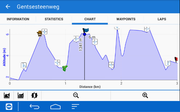
In this way I have no info on axis and no info on the chart.
The waypoint marked as picnic is not shown in the proper way, it's a waypoint with different icon.
This is not the solution if you enable label there are too many red arrows. Why we can not have what locus is already present?
Look at the attachment

Inviato dal mio SM-A520F utilizzando Tapatalk