Menu

Show posts

This section allows you to view all posts made by this member. Note that you can only see posts made in areas you currently have access to.

Show posts Menu

Topics - Andrew Heard

#21
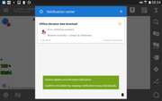
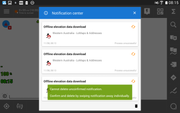
Below are screen captures of unconfirmed notifications. When I tap the Delete button I get the message that I need to confirm & delete. I can appreciated there are arguments for and against being overly cautious to not accidentally delete but I would argue to just allow users to delete unconfirmed notifications without having to swipe. I had a situation where I had multiple attempts to download elevation data, so lots of notifications. Why have the Delete button at all if you have to swipe individually?


#22
I successfully bought & downloaded a new LoMap. When I now attempt to download the elevation data:

I get an unhelpful programmer-style message below:

When I manually check with a file manager the file in question /0/Locus/data/srtm/S26E109.hgt it is indeed zero bytes in length. This file corresponds with the Indian Ocean:

There is sufficient free disc space. The folder is in default location. This file would not have previously been in the folder before download as it is a new map; so Locus Pro has created this zero byte file. Any suggestions?
#23
Recently I wanted a map from the LoStore but didn't have a wifi connection.

This screen is good (tells the user the problem in plain language):


This one is OK although tech details could be hidden from most users:


But this one (what was actually displayed) had me pretty confused as to why I couldn't access the LoStore:

until I realized I didn't actually have a proper Wifi connection. The message was quite confusing. Can it be improved?
#24
Tested with Locus Pro 3.31.0 & 3.31.1
Note below Last GPS Fix:

This field is not always reliable, and Locus no longer detects in a timely manner when GPS fixes are lost.

To demonstrate: I obtain valid GPS fixes then put the phone in a faraday cage (eg. microwave oven!) to ensure there are no further fixes/ GPS signals but the time will still increment for a further 15 seconds or so before a lost GPS notification is observed (heard). The Last GPS Fix field cannot be real/ possible. The time should immediately stop if no signal is received.

I made this simple test to demonstrate a more real-life experience when the phone was taken inside my home but over 10 minutes later there was still no lost GPS notification - GPS icon on main screen was still green. No Wifi or cellular radio was on/ enabled at the time either. I then turned on the display and a few seconds later there was a lost GPS notification and the GPS icon turned orange. It could not just be a coincidence.

Unfortunately and maybe this is Android "fooling"/ telling Locus there are valid location updates? In which case there may be few/ no options to improve the situation.
#25
I bought a new map obtained from the Locus store yesterday but now find the SRTM/ HGT/ elevation data was not downloaded or offered for download. Previously I would be asked whether to download this data. I eventually found this topic http://docs.locusmap.eu/doku.php?id=manual:faq:how_to_add_map_shading which has an old? screen capture of an example map properties page and link to "Download of elevation data" but none of my LoMaps have this button/ link. There are no items in the map ... (vertical dot.dot.dot) menu. Does this page need updating?

When I follow the instruction on this page to add then edit a POI then tap GET altitude button it displays the same (outdated?) map shading page.

BTW when I try to search the online manual for keywords "SRTM" or "HGT" eg. http://docs.locusmap.eu/doku.php?do=search&id=hgt most of the results are for DE or CZ languages, and certainly the link faq:how_to_add_map_shading is not in the results list. There are only 2 english results in the list which seems very odd. On the other hand if I search for "elevation" eg. http://docs.locusmap.eu/doku.php?do=search&id=elevation all of the results are in english, the map shading page is top of the list. No results for DE or CZ languages are listed.
#26
Even when track is being recorded and GPS is stable, locked on and satellites displayed the Track Recording & GPS function buttons are gray instead of showing red and orange color respectively. I've only noticed this two times in last month, so it's not related to just the latest version. I think it may be related to auto backup although hard to believe. My phone is normally turned off, and I use it primarily for running Locus Pro. The two times I have observed this problem when phone is turned on & I have tapped the Locus Pro icon it has displayed an annoying message - "can't start, performing backup" or words to that effect - I try a few times until backup is finished & Locus starts. This is the only unusual thing I can report may be related.

To state problem another way: I go into GPS/ satellite screen - all OK - tap Back button - GPS function button is gray instead of showing orange.

I go into the track recording screen - track is being recorded - tap Back button - Track Recording function button is gray instead of showing red.

As a potential suggestion regards the message - "can't start, performing backup" - instead could I suggest more user-friendly behavior - display "please wait - performing backup" and then starting Locus as normal once the backup is complete?
#27
ref. https://www.openstreetmap.org/edit#map=16/-42.5132/147.6463
or ref. https://www.openstreetmap.org/#map=16/-42.5132/147.6463
way is C318 Buckland Road, Tasmania, Australia
south of this point at 90 degree turn the way is marked unknown, although in actual fact is sealed
north of this point the way is correctly marked as unsealed
I can't find any Locus theme that distinguishes between unpaved & unknown surface. Often important for a road cyclist. But to be fair, displaying this section of road in OSM, Google Maps, RWGPS, and BRouter Web, with all possible themes, there is sadly no difference between the two sections either. The surface history has not changed for a long time, but to be sure I bought the latest Locus vector map anyway (30/10/2017).

Any suggestions?
#28
Our hard working friend @0709 has created a very interesting and insightful test track to expose some current shortcomings with Locus slope filtering. What it shows is a smearing of track slope resulting a deceptively lower % at places where the slope is changing. Because SRTM elevation data is only every 30 x 40 metres it may not be possible to improve the situation much but I thought I'd ask...

Does this really matter? Well say there is a short sharp upcoming hill, say +20% slope, but only for 300 metres. Locus may only show this tortuous climb as +10%.

As shown here in Garmin Basecamp (also similar in Gps Visualizer) the attached test track has precise transitions
from 0% to 25%

Basecamp displays the slope accurately as 0%, +25% and -25%.

Locus on the other hand has quite aggressive filtering. The first +25% 'hill' starts at exactly 1.9km but the Locus chart shows the slope slowing increasing at 1.5km and only reaches the proper +25% at 2.3km.


If the track style is set to manual slope coloring -25% to +25% you would expect the color to be green from 0km to 1.9km then dark red/ brown after 1.9km. But instead the color starts changing thru various shades over a distance of 500 metres, starting before the hill even begins:


One real-world shortcoming is when a steep slope is less than 500m long. For example below the 25% slope is 200m long, then flat again. Locus calculates the slope as only 15%. And the track color is pale green/ orange for only 100m.

#29
ensure settings > tap on track: popup, not screen

tap on track > track info > tap on greater than > menu popup > tap on Show on elevation chart > 1st tab of track info is displayed and chart tab should then be selected/ chart displayed, but isn't.

#30
I normally set chart X axis to distance, but today needed to accurately measure time stopped (3 places). To my surprise these times @ 78, 106 and 281 minutes show non-zero speed! All 3 times the line is perfectly straight over periods of many minutes (5, 14, 4 minutes respectively), clearly unlikely for a cyclist of my ability. It appears the speed at beginning of the stop is displayed as last non-zero speed, and straight line is then drawn to first non-zero speed once riding again.
Settings:

Black vertical lines show period while speed should be 0km/h:

#31
Offline address search > South Australia > city:Adelaide > street:"shearwater drive" is not found
map: Oceania/ Australia/ south_australia.osm.db
I bought the latest version for confirmation just in case, but no change: 2017/07/22

lat/lon and street clearly shown in screen cap below:


other search results are valid:

#32
I have noticed a difference in navigation simulation operation between me and 0709. See https://youtu.be/VLw6R1zqY0I - Willy has GPS turned off - navigation simulation - and TTS voice (beeps) are correctly heard as each waypoint is approached.

But when I perform the exact same with his supplied track and nav_audio files, no TTS voice is heard. If instead I use a GPS simulator eg. Lockito each waypoint is correctly announced, same as 0709.

So a question with my setup, why should navigation announcement occur with "proper" GPS (GPS icon green) but not with GPS simulation (GPS disabled, dragging map)? Thanks for any advise.
#33
Observation: Locus will (sometimes) start in guiding mode (ignores the first waypoint/ navigation command) but with the same track other times starts correctly in navigation mode (displays distance to first navigation command). It is not dependent on whether I "Add new route" in Locus or use To/From quick-point BRouter method.

With a very simple track Locus starts 100% reliably in navigation mode.

I have also found a workaround - while guiding then tapping "Recalculate" Locus then always goes into navigation mode and displays the next waypoint (navigation command if any).

I don't know whether this applies more widely than with using BRouter as a navigation source because I only use BRouter. I hadn't experienced this problem before BRouter 1.4.x, but then again I haven't used navigation for a few months.
#34
I recently installed BlueStacks so I can use Locus Pro with Windows. It worked very nicely, easy to setup but I uninstalled when it started asking for a monthly subscription fee or having to "rate" some silly game apps. So I am now trying Genymotion (free/ private). Lots more work to set up, more focus towards developers, and sadly not working properly yet for Locus. I managed to install Google Play Services and I've been able to install other apps OK. But when I run Locus Pro 3.12.2 and get the once-off request to download the 5MB "additional data", and I click OK, I then get an error 1810. If I follow the link it goes to Locus online manual: main > manual > faq > libraries_at_start but no mention of 1810. I assume it is related to Google Play or Google Play Services, some Google API error code? but as I've said Genymotion seems to be working for other apps. Any thoughts? I can't find any references to "1810" in this forum. Thanks.
#35
Free chat / forum problem
May 06, 2015, 12:34:51
sorry for all the identical posts - each time I click "Post" I got this stupid error below

some special character in the post text? does it happen to anyone else?
#36
Information / forum - helpdesk
April 10, 2015, 01:19:58
It would be nice if Locus just had one "forum" instead of reading duplicate/ parallel discussions in two different "forums" -  http://help.locusmap.eu and http://forum.locusmap.eu. I know forum.locusmap.eu was first. Maybe a phase out of this somehow, with everyone having to move to help.locusmap.eu after certain date? help.locusmap.eu seems better in all functionality respects.
#37
I have only just come across this forum - http://forum.locusmap.eu.
Up until now I thought all discussion had been at http://help.locusmap.eu. That's where I had created all my topics.
They appear to serve the same purpose.
What is the difference?