Menu

Show posts

This section allows you to view all posts made by this member. Note that you can only see posts made in areas you currently have access to.

Show posts Menu

Messages - locuscycling

#16
Thx . 
Finnaly i found it .
(Sorry for stupid question )


#17
I don't where can i found and turn on ANT+ in new version of Locus.

I see something like in previous version

but here i have no choice.

#18
Wishlist / Re: Elevation signs on track
February 25, 2014, 20:34:31
Thx,  good that it is independing of real Altitude.

I have to try .
Interesting how good it is on small lets say 1-2 km hill.
Garmin sometimes catches even small difference.
#19
Wishlist / Re: Elevation signs on track
February 25, 2014, 19:59:17
Thx Gynta
This is exactly what i saw on TwoNav. Once tried then I  forgot about it.
But still i think ''elevation signs'' can be at least  complementary to this colours.
This ''winter'' I made few bicycle trips with my brother Etrex 30, since then i like  ,,elevation signs''  very much.


Moment -
Red colour means we are on the top of the hillon our track  or we are just on  high altitude  in this case more then 2000 meters ?

For ex when you created route  ( on normal poved roads) from Insbruck then Solden to Tiefenbachgletscher on about 2800. How it would looks like ? 


@Christian
I know in Locus we can see information about the track , chart ascent, descent etc .
But this little icons we see  on the map we don't have to seek, think and click anywhere.
In Garmin they are appeared automatically after you press ,,GO'' along selected track.
( Unfortunatelly tracks  can not be created  in Etrex  they  have to be imported for ex from BaseComp or..... Locus what i did.)
#20
Wishlist / Re: Elevation signs on track
February 25, 2014, 19:39:18
Can you show little screen how it looks like.
Today i don't have Android with me, can not try.
#21
Wishlist / Re: Elevation signs on track
February 25, 2014, 18:46:05
Quote from: Christian on February 25, 2014, 17:35:24
Do you know settings for track color depending on altitude in Locus?
You don't need any additional signs.

Sory I dont know how it works.To say true i have problem to set colours of the track in Locus. I wanted for ex, red but on map i see orange.
I remember something like this ( coluor depending on altitude)  in Two Nav  on Pc in CompeGps Land but it was not so readable. In my opinion signs are easier to interprate.
I don't need altitude on every points of the track it is enough  only to see where there is top or bottom of the climb.

(Ok, to have coloured track we can assume where is the Top of the Hill or where is the Coll but we have to .. think a little bit.)
#22
Wishlist / Elevation signs on track
February 25, 2014, 11:19:47
Gennerally i don't like Garmin software but there are few interesting solution for cyclists (not only), mostly in ,,Altitude area.

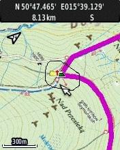
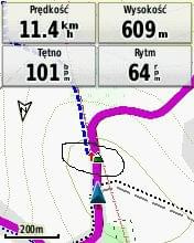
See screens
      

There is a pink track  and little icon = signs of elevation. Signs are on the top of  the hill or on the bottom.

Then when we make zoom bigger( compared with screen 1)  we can see like this:
https://www.dropbox.com/s/xyrzlrtg9j8m7hp/2779%20paint.jpg    
https://imagizer.imageshack.us/v2/352x440q90/62/x3bk.png  
https://www.dropbox.com/s/je5b7xkkvj3sr94/2779.bmp    All screens  raster maps in jnx format

Or on vector map

https://www.dropbox.com/s/ab7qs0qlt5uiu9c/7531%20%20paint.jpg
https://www.dropbox.com/s/wge41p9k4dhwyal/7734%20%20paint.jpg 
https://www.dropbox.com/s/ab7qs0qlt5uiu9c/7531%20%20paint.jpg
https://www.dropbox.com/s/ktdrhb0dgrzimeh/7734.bmp
https://www.dropbox.com/s/khyp2bcnni6ldzl/2888.bmp

Here https://www.dropbox.com/s/07jaiiqarkde08o/526%20paint.bmp sign shows end of Downhill (begining of uphill).

Of course signs are not always  100% corectly placed it depends of Srtm/Dem files, but it is nice to see this elevation signs when cycling especilally in hilly regions.


Mod:
removed wrong links
#23
Quote from: jusc on January 28, 2014, 15:50:14
Even if you you tap on the route you can´t save it with another name, or?

Probobly you mean- created route not by ,,Add new route and measure''    right???

In case of ,,Add new route and measure''   it is very easy .
a) create route
b) save ( write a name)
c) tap on map
d) export and you have gpx
#24
Quote from: KaHeMu on January 22, 2014, 10:41:18
Hast du eventuell die Punkte from, to, via1 - viax bereits vorher in Locus erstellt und abgespeichert?

Endlich 0.98 Brouter  fur mich  funktioniert.
Ich habe meine alle (ca. 13000) Punkten geloscht and alles Ok auch, auto mode, Danke.
#25
Quote from: KaHeMu on January 22, 2014, 10:09:12

1) Brouter nach Installation starten, Routingprofil auswählen, Servermode einstellen und zum Schluss und letztlich die Servicemodi auswählen die ich brauche. Sollte ich später andere Einstellungen brauchen, starte ich Brouter eben nochmal und ändere nach Wunsch.


Leider auf meine Xperia Active es geht nur zur ,, Routingprofil auswählen''  danach kommt Foto nr.2.

1. - 2.

3. ->  oder 

Folgende Anzeige habe ich nur bei Tablet( Galaxy s3 T310) gesehen:

#26
[ENG]
The same in with my Xperia.
I went back to old 0.97 or 0.96 version of Brouter  and it works normally.
#27
I know here https://getsatisfaction.com/locus/topics/altitude_profile is a topic about implementation altitude chart in Dashboard  i also hope for it in the future.

Now we have for ex. possibility to see like this:


But to see this chart we have to make 3 clicks :first  on the point of the map , then click settings and last one ,,see chart''. 

I think it will be practical to have possibilitty to set ,,Altitude Chart '' in right panel.

''Altitude Chart''- I mean- we import or create  a route to Locus ( see it on map)
Then when travelling    just click on right panel ( Altitude Chart) and we know what is ahead and what we have done.

Even simple chart like in Garmin for ex. is sometimes quite useful
(green - what we have done , blue what's ahead):


#28
Maps / Re: rmap/squlite maps onn PC
November 19, 2013, 21:12:58
And Locus read easilly maps 3,5 gb???

I created  maps in Mobac in zoom 15 ( for ex. French Mountains have  ca. 8 gb divided for 4 regions Alps, Pireneos,Jura and  Massif Central  and every  region contain  3- 4 maps ca. 800 mb,each , Spain it is ca. 6 gb  Austria , Italy ...etc.)

It is not a problem with SD CARD , I just want to see this squlite maps on PC but don't know if it is possible.
Unfortunatelly i don't have Tablet with 10 '' screen and Android  where i can probobly install Locus.
#29
Maps / rmap/sqlite maps on PC
November 19, 2013, 19:15:26
I have made few big (ca 1gb) maps (rmap/sqlite format) in Mobile Atlas Creator and wanted to see this maps on my Deskop ( or Laptop) is it possible?
I spent some time but was not able to find a software which can read this rmap/squlite format on PC.

I know, Locus read big maps but the problem is that my MICRO SD (32 gb) is almost full and every time  to try new created map i have to deleted something from the Card.

(Before, I used all maps in TwoNav Rmap (is it possible to open this format  via CompeGpsLand)  format ,but now I  wanted to work with MIXMAP option in Locus, i like this.
#30
Wishlist / Re: Power in watt- ( algorytm and ANT)
November 09, 2013, 18:09:11
Quote from: menion on June 25, 2013, 06:17:22
hi, currently I have some serious problems with ANT+, where some sensors do not works at all. When this will be fixed, remind me this and I'll look at it. I also write this topic to my private list of "TODO", so I'll probably not forget <!-- s:) -->:)<!-- s:) -->

Hallo,
I think  all problems with ,ANT+ were fixed and  it work  excellent.
Just wanted to remind you about  possible implementation of ,, Power from ANT + or ''Power from Algorithm'' in Locus.

( Of course it is not time to ride a bike  right now but it will be nice to see ,,Power calculation'' in Locus Dashboard in some time.)