Menu

Show posts

This section allows you to view all posts made by this member. Note that you can only see posts made in areas you currently have access to.

Show posts Menu

Messages - john_percy

#586
1. Thanks for the orientation lock option in the presets. Does just what I needed to give reverse portrait when navigating in the car.
2. Something seems to have changed with the icon for the app. My Nova launcher processes the desktop icon with a white surround.


Sent from my XT1039 using Tapatalk

#587
Google Search is working for me but what seems to be the case is that the search is much more restrictive now if I tick "Search around your location" than it was. It appears to search within a more limited radius of the map centre. If the location being searched for is 80 miles away, it is too far, but 40 miles away is OK.
Quote from: Henk van der Spek on October 11, 2018, 20:01:52
Ok. Then I have a new problem. The standard search (Search address online) works only in Bing and GraphHopper, not in Google. Version 3.33.2
#588
I read elsewhere recently that Google had substantially increased the licence fee to use this functionality.
#589
3.33 Locus Free "Navigate to" crashes. Both with Brouter offline and Graphhopper online engines. Both via popup on point and button in side menu.
Perfectly ok in Pro version.

Sent from my XT1039 using Tapatalk

#590
Graphhopper hike and bike routing data are available once again at https://graphhopper.develar.org/ .
Car routing data is not currently available as it does not work satisfactorily (I presume).
Thanks to develar.
#591
Maps / Re: USGS PADUS public land ownership overlay
September 21, 2018, 13:42:54
I suggest you try changing the code in providers.xml as below
   
   <provider id="1000" type="0" visible="true" background="-1">
        <name>USGS</name>
        <mode>PADUS Manager</mode>
        <url><![CDATA[https://gis1.usgs.gov/arcgis/rest/services/PADUS1_4/Protected_Areas_by_Manager/MapServer/tile/{z}/{y}/{x}]]></url>
<zoomPart>{z}-8</zoomPart>
        <zoomMin>12</zoomMin>
        <zoomMax>20</zoomMax>
        <tileSize>256</tileSize>
        <countries>World</countries>
    </provider>
#592
That refers to a limited access highway restricted to motor vehicles only, as in a motorway, freeway, turnpike, autoroute, autobahn, autostrada etc.

Sent from my XT1039 using Tapatalk

#593
"Personal details" setting asks for my height in yards. I don't know of any country that measures personal height in yards. For both Imperial (UK) and US (Queen Anne) measures, feet and inches would be best.

Sent from my XT1039 using Tapatalk

#594
I think you need to ask elsewhere: https://plus.google.com/105415797711448238292 though you may not get an answer as the group seems pretty inactive. Or you could go straight to the files: https://github.com/mjk912/LocusMapTweak

#595
Did you check the link for symbols in the Elevate key?
http://www.sjjb.co.uk/mapicons/contactsheet


Sent from my XT1039 using Tapatalk

#596
The Hiking style of the excellent Elevate theme gives some very detailed information, which is customisable to your taste.
Personally, I find it too detailed for my rather tame use and you might like to look at the Hiking style of my Voluntary theme, mentioned above. In the end I think it depends on how wild your walking is going to be!
#597
The andromaps themes are deprecated and no longer supported. I thought they didn't scale, and I am surprised they appear to scale in reverse! [Edit: Sorry, as Tobias points out below these screenshots are not from the andromaps themes.]
The Elevate/Elements themes on the OAM site are more up to date though not fully optimised for the Locus app or LoMaps.
You could try one of the built-in Locus themes or my Voluntary theme (available for free from the Locus store, or here, which are designed to scale subtly on zooming.
The best theme to use depends on your intended purpose and the map you are using. There are other free themes on the Locus store or this forum which may suit your purposes better.
#598
1. rotate="false" works on the Mapsforge renderer (used for OAM Multilingual maps) but not the Locus renderer (used for LoMaps and OAM single-language maps).
2. pathtext fits text to single straight segments of the way. If the segment is too short the text won't fit and won't be displayed. If you reduce the size of the text, there is a greater chance it will fit into any given segment.
3. Your coding looks like it is written for the mapsforge renderer. The Locus renderer doesn't support position, priority or symbol-id. It does however support resolution-aware sizing using dp and scaling on zoom. Use something like:
<caption k="name" dy="14dp" font-style="bold" font-size="10dp" scale-font-size="18,1.1" scale-dy-size="16,1.15" fill="#000000" stroke="#80FFFFFF" stroke-width="2dp" />

I think dx may work in place of dy above but you'll have to test it.

For more (but limited) info see http://docs.locusmap.eu/doku.php?id=manual:advanced:map_tools:theming - which is unfortunately not altogether correct!
#599
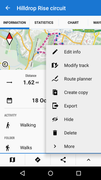
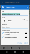
The option to reverse the track only appears from "Create copy" from the "^" on the track detail screen which you get by tapping on the track displayed on the map. The screens are illustrated below.
It does not appear if you copy a track using the Data | Tracks | [select track(s) | [wrench icon] | [copy icon].


#600
Quote from: menion on July 28, 2018, 13:47:43
This problem is not so unusual. It happens to me personally maybe twice already.
Unfortunately, nice exact steps do not lead to the same issue on my device. Will try it next week on colleague Milan's device, who just a few days ago told me that same issue happen to him as well. Thanks
On the face of it, it looks like the Back button is going back to the logon success screen which then redirects to the page I was at before I logged on, which is the map description page in the store.


Sent from my XT1039 using Tapatalk