Menu

Show posts

This section allows you to view all posts made by this member. Note that you can only see posts made in areas you currently have access to.

Show posts Menu

Messages - john_percy

#556
Themes - Vector maps / Re: [Theme] Voluntary UK
January 02, 2019, 00:38:58
New version available in the first post in this thread.
The most significant changes are revisions to dashed lines for better compatibility with devices with later Android versions and the incorporation of Mapsforge v4 (multilingual) versions.
Plus, of course, numerous other small tweaks and improvements.
#557
The only question I have that remains is whether you set up the GraphHopper data directory selection, which you can either by running the add-on itself directly from the apps drawer or from the routing settings in Locus. Otherwise you appear to have done the correct steps.

It might be worth uninstalling the add-on and then reinstalling both it and the data. It also might be worth testing one of the other methods for navigation in Locus  (three illustrated below) but beyond that I don't know what to suggest it. It all works smoothly for me


Is anyone else able to help?
#558
I'm not clear exactly what you have done nor exactly what went wrong, so could you please explain your steps a bit more.
Did you install the add on from the link in this forum? And then also the routing data from the link in the same post by clicking on the Locus link? And then run the add on (or go to Navigation settings) to select the folder with the routing data?
You obviously have selected Offline Graphhopper as the preferred routing engine.
If so, when you use any of the Locus methods to navigate to a point you should get a pop up to choose between fast car, fast bike, mountain bike, racing bike or hike.


#559
This is speed auto-zoom. See http://docs.locusmap.eu/doku.php?id=manual:user_guide:maps_settings:misc#speed_auto-zoom
It's now found in Settings > Controlling > Map screen > Zoom according to speed 
#560
Quote from: john_percy on September 24, 2018, 13:34:28
Car routing data is not currently available as it does not work satisfactorily (I presume).
Car routing data is now available for download again at https://graphhopper.develar.org/#maps (as in the first post in this thread) along with

  • pedestrian or walking with priority for more beautiful hiking tours (hike)
  • trekking bike avoiding hills (bike2)
  • mountain bike
  • racing bike
This seems to work fine with the Locus add on (link in the first post again), though avoid highways/tolls/unpaved road options are not available.
Thanks again to develar.

#561
Quote from: john_percy on December 15, 2018, 16:41:20
There's some trouble with hill shading in Mapsforge version 4 - some portions of tiles are missing at some zooms.
Map is OAM Great Britain, theme is internal.

No one responded, so I'm wondering if no one else has this problem or if it's been overlooked.

Sent from my moto g(6) plus using Tapatalk

#562
I use the Locus World base map from the Locus Store for improved speed at low zooms when using vector maps. I note it does not switch in if I am using a Mapsforge v4 map.  :(
#563
There's some trouble with hill shading in Mapsforge version 4 - some portions of tiles are missing at some zooms.
Map is OAM Great Britain, theme is internal.

#564
Link to OAM post in English: https://www.openandromaps.org/en/locus-direct-install-link-for-multilanguage-v4-maps

Locus enhancement for v3 includes
- controllable intelligent scaling (resolution-aware) of text, symbols on zooming
- proper treatment of dotted or dashed lines on zooming, so visual spacing stays constant
- fancy labels for roads etc
- ability to display contour lines as smoothed curves
- ability to render elevation text of contour lines "looking up the hill" (switch off rotation of pathtext for "normal" viewing)
- uppercase transformation of text
- dx shift of path text
- dy shift of pathtext understands if text has been rotated for "normal" viewing
- speed enhancements

Someone can probably add to this list which I've just done from the top of my head

#565
Version 3.35.1 restores the style pop-up menu, thanks.
However the map themes I set previously in presets are not applied, though they show on the details of the preset. I had to edit the preset and reselect the theme, then it worked.

Sent from my moto g(6) plus using Tapatalk

#566
Quote from: balloni55 on December 10, 2018, 13:00:20
cant reach any switchable layer of internal and external themes ::)
Already noted #2, #3 and fixed #4!

#567
@menion Of course, it hasn't crashed since the first three times! Could you point me to the instructions for sending a bug report, please.

Sent from my moto g(6) plus using Tapatalk

#568
1. New version "stops" (crashes) unaccountably from time to time. Possibly linked with moving map centre(?) :(
2. Cannot access the different styles of custom themes in new version. Tried a phone restart but no difference. I've checked bug on both Tobias's Elevate/Elements and my Voluntary themes -- there seems no way to access the Styles menu. Connected to changelog item: "fix: incorrect icons of popup menu selector of custom themes" (?) >:(
Edit: Styles pop up menu still works on Mapsforge v4 maps.
#569
Quote from: menion on December 03, 2018, 09:06:30you know that app has some more serious problems with labels because of the older part of MapsForge V3 library.
I am aware of the problem with labels and Mapsforge v3 library. But this is a Mapsforge v4 multilingual map -- doesn't that use v4 library?
The usual problem is labels not extending outside the boundaries of the tiles -- this is almost the reverse: the label is only displayed outside the relevant tile.
In any case, the issue is not simply to do with rendering as the map displays correctly on switching to it from a standard map but incorrectly on changing zoom. The standard maps don't display this effect.
#570
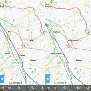
Using a Mapsforge Multilingual map of Great Britain from OpenAndroMaps and any theme (eg internal General theme or my Voluntary ML theme) I'm finding that zooming from ZL15 to ZL14 results in portions of the text layer not being drawn (left). The text layer is drawn if I change to a standard LoMap and back to the ML map (right).
Example: Long Buckby N52.29568 W001.09262: