Menu

Show posts

This section allows you to view all posts made by this member. Note that you can only see posts made in areas you currently have access to.

Show posts Menu

Messages - balloni55

#121
@balloni55 The Germany (Complete) really doesn't contain the offline addresses and for this reason has DB file lower size then current Germany South LoMap
The following users thanked this post: balloni55
#122
Quote from: balloni55 on December 10, 2018, 13:00:20
cant reach any switchable layer of internal and external themes ::)
Already noted #2, #3 and fixed #4!

The following users thanked this post: balloni55
#123
Ich habe es mal vorgeschlagen.
The following users thanked this post: balloni55
#124
ohne "ie"

:-*
The following users thanked this post: balloni55
#125
Hi Guys,

I did a minor extension of the Elevate and Elevate LE themes provided by OAM from their webpage and for usage with the OAM: I added some lines which allow to switch on a new option when selecting maps layout. The new option is called "MTB+Hiking routes" and it does what you would expect: you can have the MTB layout where you enable and display hiking routes additionally.

The files are availble from my webserver in two flavors:

To use the modification, simply download the zip file and extract the content (2 folders) into /Locus/mapsVecor/_themes/ on your device running Locus Map. The files could be easily used in parallel of any other themes. Enjoy!

Please let me know what you think about the modification.

Best regards

Bernhard

Update Feb 18, 2018:
Updated the files base don latest OAM Themes released on Feb 13, 2018. Latest maps required to benefit from all updates!
The following users thanked this post: balloni55
#126
Quote from: raydavids on December 26, 2017, 17:42:17
Hallo!
Habe jetzt Field Notes auf Pro umgestellt damit ich meine Logs einsprechen kann. Leider finde ich diese Funktion nicht. Kann mir jemand bitte weiterhelfen.
Danke im Voraus.
Gruß Ray.
P.S. Das Symbol zur Spracheingabe fehlt.
Zum Einsprechen kann man doch auch über die jeweilige Tastatur-App die Mikrophonfunktion nutzen. Da braucht es doch keine extra Funktion in der App .
Oder habe ich die Absicht falsch verstanden?
The following users thanked this post: balloni55
#127
[DE] - deutschsprachiger Forumsbereich / Danke
December 23, 2017, 11:40:06
Schöne Weihnachten an unsere Moderatoren. Ihr habt mal wieder eine tolle Arbeit geleistet. Aber auch alle anderen die hier täglich verzweifelten User weiterhelfen.
Danke an Alle !

Gruß Freischneider
The following users thanked this post: balloni55
#128
Source: Tiramisù 3.0.2 for Oruxmaps and MapsForge compatible applications
http://tartamillo.wordpress.com


**********************************************************************
*  Great thanks Maki for such a Grand work and a sense of beauty!  *
**********************************************************************


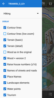
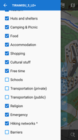
Now able to work in Locus. Some layers have been added. This theme is only for maps version 3. (lomaps and other V3)
Redone the "scrub", now this is a clarified version of the forest from version 2.
The "wood" is now correctly displayed taking into account the type of foliage and has a different shade, for example, coniferous - darker. Increased object signatures, house numbers, regrouped layers
and many many other small things ....

[ 
Satellite map  + overlay Lomaps with the included layers of tourism and huts only ... everything else is off

Updated to 3LE+5 (12/02/2018):
- slightly increased the visibility of the trails
- buildings names in Place Names
- underground waterways
- intermittent streams and rivers (OAM only)
- embankment's  (OAM)
- and the little things are different
The following users thanked this post: balloni55
#129
Hallo balloni55,

das FiledNotes AddOn in der Version 1.4.6.1 macht einfach keinen Spass mehr.

Folgendes habe ich zwei Mal durchgeführt:
(1.) V. 1.4.6.1 deinstalliert
(2.) V. 1.4.5.1 via APK installiert
(3.) ==> PRO-Icon vorhanden, 10 optionale Vorlagen, Spracheingabe beim Loggen möglich
(4.) V. 1.4.6.1 aus Google Play Store installiert
(5.) ==> PRO-Icon vorhanden, nur 5 optionale Vorlagen, Spracheingabe beim Loggen nicht möglich

Dann habe ich die V. 1.4.6.1 deinstalliert und direkt aus dem Google Play Store wieder installiert. Ergebnis:
(1.) ==> PRO-Icon vorhanden, nur 5 optionale Vorlagen, Spracheingabe beim Loggen nicht möglich

Dank Dir also schleunigst die V. 1.4.5.1 wieder installiert und die bleibt jetzt auch erst Mal drauf!!

Gruß
c.s.g.
The following users thanked this post: balloni55
#130
Quote from: balloni55 on July 06, 2017, 11:55:50
let´s try it in your wording,

attached screencast start with restored backup of my  "Geocache" preset
sec 7 - i restore my "Basic Setting" preset
sec 18 - i edit function panel  of "Basic Setting"
sec - 27 i add function "Weather"
sec 30 - "Weather" is added to list
sec 34 - back to map view, "Weather" isn´t visible :-[
sec 42 - back to presets an restore "Basic Setting"  once again
sec 44 - back to map view, "Weather" is visible :)
sec 58 - i remove "Weather"
sec 62 - back to map view, "Weather" is furthermore visible :-[
sec 69 - back to presets an restore "Basic Setting"  once again "Weather" is´nt visible

https://www.dropbox.com/s/s6f9hf862ewtiz7/Preset.mp4?dl=0

please read menions post carefully again:

Quote from: menion on July 05, 2017, 20:51:35
@balloni55: seems there is still a problem with understanding "presets" :). There really is not anything like "active preset". It is just a bunch of settings that, after click, is set. Imagine it like "backup of settings", that you simply restore by one click, nothing more!

Your observed behaviour is exactly as it is intended. There is no "active preset"!!! This also means, that the changed settings of the preset are not applied until you "run" or "tap" the preset.

Another try for explanation: try to think of a preset as a list of instructions (like a batch file or a computer program) for settings which can be "processed" by tapping on the preset. If you change something in this list, it is not automatically applied but only when you process this list (in Locus: by tapping the preset). Similar to when you change some lines in a batch file and save it, it is not executed automatically.
The following users thanked this post: balloni55
#131
Quote from: Andrew Heard on March 09, 2017, 23:23:43
@twil69 - the notification button is not permanent - I'd complain too if that were the case. Easy to dismiss any new items and button will hide. Don't stress too much.

Well, technically you may be right.
But lor74cas described quite nicely what will happen most of the time: this thing will disturb you when you have no time to deal with it and just want it to go away. And when you do have time you will not remember.

So it is more about the perception as something useful or something annoying. And since there are established notification alternatives (that most apps seem to agree upon) I dont see why Locus needs something different.

I always prefer pull mode (deal with things when I have time for them) instead of push mode (being interrupted).
The status of a download is visible in the Android status bar and when I want to read the Locus blog I go to feedly. Everything is already there. I personally dont need more. But let the user community decide.
The following users thanked this post: balloni55
#132
Hallo, ich versuche es so "kurz"  ;) und verständlich wie möglich zu erklären:

Für jene Gebiete wo es bereits meine LIDAR-DTMs gibt, z.b. für Österreich http://data.opendataportal.at/dataset/dtm-austria , lädst du dir jeweils die 1"-DTM runter. Hier findest du übrigens auch einen Link zum Kartenvergleich meiner LIDAR-Daten zu denen der SRTM-Kacheln: http://goo.gl/DM2YxD

Das 1" ist das genaueste DTM, es gäbe auch noch die 3" die aber ungenauer sind. Mit den 20m und 50m-DTMs kann Locus sowieso nicht umgehen.

Du entpackst alle Dateien und schiebst die .hgt Dateien rüber in den data/srtm-Ordner von Locus. Dort liegen ev. schon Dateien mit dem gleichen Kachelnamen drin, die überschreibst du einfach, denn dabei handelt es sich vermutlich um die "alten" wesentlich ungenaueren SRTM-Höhendaten.

Sodala, da war's schon. Ab nun nimmt Locus zur dynamischen Anzeige der Höhe deiner aktuellen Position ("Dynamic Elevation", zur Berechung von Höhenunterschieden eines Tracks, zum Erzeugung der Kartenschattierungen ("Map shading") dieso genauen Höhenkacheln her.

Diese Höhendaten sind so gut wie immer genauer und zuverlässiger als die Höhenbestimmung per GPS oder auch per Barometer (dieser folgt zwar Höhenänderungen sehr genau, muss aber manchmal nachkalibriert werden, da sich der örtliche Luftdruck ändern kann).
In den Locus-Einstellungen (Menü > Settings > GPS > Altitude manager > "SRTM DATA" kannst du einstellen:
"Optimimize GPS values" (gerade in Zusammenspiel mit einem Barometer sicher eine interessante Sache) oder gleich "Replace GPS values", dann werden ausschließlich diese Höhenkacheln zu Höhenberechnung herangezogen.

Etwas anderes ist die Lage für Länder, wo es solche LIDAR-basierten DTMs noch nicht gibt, sonder nur die SRTM-Kacheln. Diese können zuverlässiger sein als GPS-Höhenempfang, aber auch ungenauer sein, da die SRTM-Kacheln stellenweise Abweichungen von 50m,100m oder mehr haben können, z.B. im alpinen Gelände, in Schluchten etc.
Speziell in gebirgenen Regionen und/oder dicht bewaldeten Flächen würde ich hier zuerst auf barometrische Höhenmessung zurückgreifen falls im Gerät vorhanden.

Zu deinen Zusatzfragen:

- Es kann immer nur eine gleichbenannte Kachel geben und diese erwartet Locus im data/srtm ordner.
Dabei sollte es sich hier immer um die genauest möglichen Kacheln eines Landes handeln (1"-Lidar besser als 3"-Lidar besser als 1"-SRTM besser als 3"-SRTM)
- Wenn du einen Track z.B. für eine Navigation im Vorhinein erzeugst, dann basiert das Höhendiagramm definitiv auf den Höhenkacheln.
Wie dies aber bei der Aufzeichnung eines Tracks ist während du unterwegs bist, weiß ich nicht. Entweder es werden auch hier standardmäßig nur die Höhenkacheln genommen oder aber jene Höhe die Locus live ermittelt anhand der obigen einstelllungen bei (Menü > Settings > GPS > Altitude manager > SRTM).

Müsstest du menion dazu fragen, oder jemand anders der das weiß.
The following users thanked this post: balloni55
#133
Quote from: balloni55 on February 23, 2017, 15:43:36
current anouncement for "current time" in german language:
current time 13 Stunden 36 Minuten
it should:
aktuelle Uhrzeit 13 Uhr 36 Minuten
Hi, balloni55.
Please download an attached de.tts and put it as Locus/data/tts/de.tts. Then, in Locus, set both 'Language' and 'Text-to-speech settings' to german. With this configuration and google tts engine, I confirmed that announcement of current time was correct (aktuelle Uhrzeit X Uhr X Minuten). Though I don't understand german. ;)

@menion: I don't know why but it seems that leading spaces in tts file cause a problem. I replaced them with tabs and it works.

Quote from: balloni55 on February 23, 2017, 15:43:36
For now i miss to translate for announcement:
- tracktime
- pace
- lap pace
- current time  and here additional an alternative option for german language
Because these words are missing in tts file, crowdin texts are used as fallback. This fallback is based on 'Language' setting but not 'Text-to-speech settings'. So, if you set 'Language' to english and 'Text-to-speech settings' to german, Locus gives "current time X Stunden X Minuten". Am I right?
The following users thanked this post: balloni55
#134
Quote from: balloni55 on October 24, 2016, 15:23:23
ich bitte um eine verständliche Erklärung added turncost as start-direction bias (locus only) am besten an einem Beispiel 8)

Menion hat in die Aufrufschnittstelle zwei neue Parameter eingebaut, mit denen erreicht werden soll, dass eine dynamische Neuberechung mehr "nach vorne" geht und nicht schon veraltet ist in dem Moment, wo sie angezeigt wird:

- direction
- noManveuverTime

Nur ist das so zu Zeit nicht machbar, weil würde einige der strukturellen Änderungen erfordern, die auch für Abbiegebeschränkungen notwendig sind.

Aber das, was ich leicht tun kann, hab' ich gemacht: ich benutze die aktuelle Start-Richtung und rechne für den ersten Wegschritt die Winkelkosten relativ zu dieser Startrichtung genau, wie jeden anderen Winkel auch.

Dadurch rückt der Punkt, ab dem die Vorwärtslösung gewinnt, um "turncost/costfactor" Meter nach vorne man bekommt also in mehr Fällen schon bei der ersten Neuberechnung die Vorwärtslösung.

Aber wie gesagt, nur ein leichter Bias, noch kein Navi mit künstlicher Intelligenz, das raten kann, was man vorhat.
The following users thanked this post: balloni55
#135
UPDATE:
V8, 14.10.2016,
   - Wanderwegemarkierungen (OSMC:SYMBOL) ist nun auch in den OpenAndroMaps enthalten und wird voll unterstützt
   - Wegemarkierungen können nun wahlweise dargestellt werden, aber nur wenn auch Wanderwege dargestellt werden
   - Darstellung der Parkplätze erfolgt nun auch bei ausgeschalteter Option richtig
   - Darstellung der Strassen- und Wegenamen verbessert
   - highway=tertiary (Hauptstrassen) werden nun wie bei Outdooractive in hellgelb dargestellt
   - way=dyke (Deich) wird nun angezeigt, ab Zoom 14 (nur bei OpenAndroMaps)
   - highway=tracktype die Darstellung der grade1...5 angepasst um die Erkennbarkeit zu erhöhen
   - highway=bridleway (Reitwege) werden erst ab Zoom 15 und in gröberer Strichlierung dargestellt
   - natural=rock (Nackter Fels) wird nun, mit Synbol, dargestellt (nur bei OpenAndroMaps)
   - natural=scree|shingle (Schutt, Hangschutt|Schotter, Kies) wird nun, mit Synbol, dargestellt (nur bei OpenAndroMaps)
   - natural=fell (Überwiegend mit Gras bewachsene Fläche oberhalb der Baumgrenze) wird nun dargestellt (nur bei OpenAndroMaps)
   - natural=marsh Symbol nun im SVG Format
   - natural=beach Symbol entfernt
   - landuse=vineyard Symbol nun im SVG Format und Farbe abgepasst
   - Bei highway=path|footway wird nun auch die trail_visibility (Sichtbarkeit) der Wege ausgewertet (nur bei OpenAndroMaps)
   - Bei highway=path|footway und highway=track wird nun bei foot=no, ab Zomm 14, zusätzlich eine orange gepunktete Linie angezeigt (nur bei OpenAndroMaps)

Der Downloadlink ist im Startpost zu finden.
The following users thanked this post: balloni55