Menu

Show posts

This section allows you to view all posts made by this member. Note that you can only see posts made in areas you currently have access to.

Show posts Menu

Messages - 0709

#151
@uatschitchun. See > Advantages::)

Suggestion Idea Locus Route Planner.
Non existing function in actual Locus.

Router adds timestamps according to +/- realistic (personal) speed expectations.
Set your personal avg speed, visualised in the Locus % Slope trackcolor legend.
Personal variable speed within the % Slope zones by using the gpx <ele> data.
[Dark Blue_36kmh-Green_16kmh-Red_2kmh.


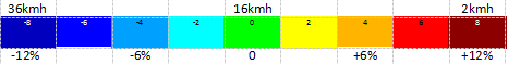
(Off bike 2kmh = non advised traject).

By the way...change or add timestamps is not critical using the trk_navtrkpt mode as the method does not need any "associated waypoint" for secure robustnavigation.

Note.
The speed specifier should not necessarily go from slow to fast.
For steep descents, the walking speed is slower than on flat terrain.

Anyway correct ETA calculations is a rather complex subject  :o
https://en.wikipedia.org/wiki/Naismith%27s_rule
#152
UPDATE ! Locus 3.50.1  Operational ! (Import)

Gpx track navigation.

Instructions in trackpoints trkpt.

Trackpoints that contain a compatible [EN]sym are promoted to navigation instruction points.
The promoted trackpoints that contain [EN]type Via are announced.
The promoted trackpoints that contain [EN]type Shaping are not announced.

Only the Turn and Via points lead to navigation alerts and give distance values @ navigation.

Advantages.

- Navigates 100% faithfull after gpx track import even without (routable) maps present in the app.
- Manage/separate the free located (poi) waypoints without any risk to damage the navigation.
- Easy import, navigate 100% faithfull without "must" set: "Merge waypoints with imported track".
- Less fragile than the trk_navwpt method with the more vulnarable associated waypoints.
- Compact POI wpt_list not cluttered by many associated wpt's as by the trk_navwpt method.
- Synced gpx files to pc offers extra edit tools or an alternative for only Locus edit.
- You can simply add multiple additional selected freely positioned wpt's(poi) into the gpx file.
- Timestamps are not obligatory but recommanded and attached according to expected speed
- A single gpx file can also contain multiple navigation tracks including turn-by-turn instructions. 
  Contains the original plus several free to select alternative navigation tracks to choose from.

The Via trackpoints by the <sym>pass_place <type>Via can have a <name>text to be announced by TTS.

@ gpx IMPORT.
Locus map app. (V3.62.1)
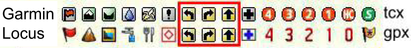
:) Turn instructions by trkpt <sym>(turn) & Via Points by the trkpt <sym>pass_place
:) A <sym>pass_place <type>Shaping trackpoint is considered to be a "Silent Via Point"
:) Roundabout support.
:( A <sym>turn plus <type> Shaping or Via in the same trackpoint is NOT supported.

Cruiser app. (V3.0.0)  https://wiki.openstreetmap.org/wiki/Cruiser
:) Turn instructions by trkpt <sym>(turn) & Via Points by trkpt <sym>pass_place and <type>shaping or via.
:) Shaping & Via Point transfers by point <type> in gpx (trk)track (trkpt) and (rte)route (rtept) or wpt.
:) A <sym>turn plus <type>Shaping or Via in the same track point is supported.
:) Straight line route planner support by the segment target trkpt <src>beeline and the BRouter app.
  https://groups.google.com/g/cruiser-users/c/zvjvDrntLj8/m/8KhFB8ZBCAAJ[/i]
:) Roundabout support.
   

@ gpx EXPORT.
Locus map app.
:( Export is not supported


Cruiser app. (V3.0.0)  https://wiki.openstreetmap.org/wiki/Cruiser
:) Shaping & Via Point transfers by point <type> in gpx (trk)track (trkpt) and (rte)route (rtept) or wpt.
:) Turn instructions by trkpt <sym>(turn) & Via Points by trkpt <sym>pass_place and <type>shaping or via.
:) Via and Shaping by type are 100% supported: By trkpt <type>Shaping is a non announced planner point.
:) U-turn & Shaping or Via Point at the same track point position is supported.
:) Straight line route planner support by the segment target trkpt <src>beeline and the BRouter app.
  https://groups.google.com/g/cruiser-users/c/zvjvDrntLj8/m/8KhFB8ZBCAAJ[/i] 
:) Trackpoint timestamps according to the transportation mode selection are attached.
:) Roundabout support.

#153
http://www8.garmin.com/xmlschemas/TrainingCenterDatabasev2.xsd

Garmin        <=>      Locus
tcx files.         <=>    gpx files.
Coursepoint  <=>    Waypoint (wpt)
<PointType>   <=>    <sym>
<Name>         <=>    <name>
<Notes>         <=>    <cmt>

Single Coursepoint attached to a Single trackpoint. Corresponding in Position and timestamp.
<PointType> tag (english).
<Name> tag (local language ok):  Text limit max. 10 characters.
<Notes> tag (local language ok):  Text with detailled Guiding info.

Garmin <PointType> .tcx
"Generic", "Summit", "Valley", "Water", "Food", "Danger", "Left", "Right", "Straight", "First Aid",
"4th Category", "3rd Category", "2nd Category", "1st Category", "Hors Category", "Sprint"

Locus <sym> .gpx
"Flag","Summit","Dropoff","Drinking Water", "Restaurant", "Danger Area", "Left", "Right", "Straight", "Medical Facility","Number 4, Red", "Number 3, Red", "Number 2, Red", "Number 1, Red", "Number 0, Red", "Civil"
#154
Navigation & Guidance / No .tcx file support Locus ?
September 23, 2014, 10:21:24
No .tcx file Import. Export .tcx file. Not compatible with Garmin Gps.