Menu

Show posts

This section allows you to view all posts made by this member. Note that you can only see posts made in areas you currently have access to.

Show posts Menu

Messages - 0709

#136
QuoteI will experiment but I assume if I set recalculate to 'point' and convert the 'START' shape point to a Via  and I'm not yet on the planned route (e.g. the route I attached in prev post) and I turn on navigation early then will I be guided to the start?

Not exactly, unless you are indeed nearer to the start.
@ Navigation start by (any) recalculation trigger: Locus recalculates toward the nearest Via Point.
All next Via Points during a normal navigation session than are served in numeric order one by one.

#137
Your start position is nearer to finish than start. NOK.

1. Only start navigate when near to the start.
2. For better understanding Navigation, DO NOT use autorecalculate mode. Select: NONE

Do not rely on automatics unless you exactly know what happens by automatic modes.

Roundtrip circuits.

Route Priority (autorecalculate) navigates toward the nearest trackpoints.
Manually trigger a recalculation Locus shows the path toward target. 
When located nearer to the finish is toward the last trackpoint.

Point Priority (auto)recalculate navigates toward the nearest medium Via Point.
If medium Via Points are missing so navigates directly toward the Finish.
#138
What is the source of your round trip navigation design ?
When you start navigation are you nearer to the start or the finish ?
Share example round trip and indicate the position where you start the navigation.
#139
Samsung ?

Use red encircled settings in pdf,  optimal for phone on bike handlebar mount.
Dismiss and wake up display by (one) wave proximity sensor action.
#140
QuoteOne other thing Locus help details What is the difference between a route and a track? But then when I create a route in route planner it appears under 'tracks' but Locus states a track provides a record of where you have been, and when. That's downright confusing

Confusing, yes. A problem caused by difference in technical language of (rte)route or (trk)track, and the popular language expression about what "a route" means.

Technical.
A (trk) track. (General)
Describes the traject by multiple position points. The traject so is precisely indicated.

A (rte) route in two variants.
a. A compact (rte) route. (Garmin)
Just contains some reference position points along which you absolutely want to go.
b. A direct (rte) route. (ViewRanger)
In addition to the reference position points, also contains intermediate points of the traject.

A Navigation track. (Locus)
Includes Navigation waypoints that do contain the turn instructions.

A track design inclusive waypoints containing turn commands is in standard language also called a route design.

A route is something you want to follow. So this can be a recorded or generated track.
#141
config.cfg.

# allows to define zoom level for tracks simplification (reducing of visible trackpoints).
# So value 20 for example means, that simplification  may occur in levels 1 - 20. (default: 22)
map_items_track_simplification_till_zoom=22

More on screen points displayed is slower !
#142
Method supported since Locus Pro V3.30.2

Navigation by gpx fileA tcx clone by gpx   ;)

A. Instructions in associated (wpt)waypoints(Import and export)

Successful navigation by (no extension) gpx (trk)track_navwpt file.
By track_navwaypoint file. Association by position AND timestamp.


If the gps end application already masters tcx course_coursepoint navigation it is relatively easy to realize a gpx track_waypoints navigation alternative succesfully. Result is even more optimal with gpx files, due to less restrictive rules. That's what Locus does.

Fine tuning your file(s) by external (pc) program edits.

By pc program gpx editor promote a trackpoint to a Via (way)Point or a Turn (nav)Point plus add freely positioned (poi)waypoints into the gpx file.

Edit the <sym>text by (pc) "gpx editor" or Notepad ++ etc.
Via Point: The prefered tag = pass_place

gpx editor: https://sourceforge.net/projects/gpxeditor/

The exact <sym>text must be known.

The Locus Navigation turn commands Icon list.
In attachment: Locus_Navigation_Icons_sym_wpt .gpx

The most important supported navigation turn commands by tcx / fit /gpx


Free text (streetname) in gpx cmt is displayed in the top panel @ navigation.

@ gpx EXPORT.
Plotaroute web.
https://www.plotaroute.com/myhome
Download this route > GPS > GPX > Track > Directions

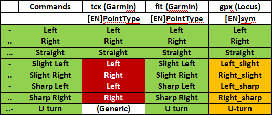
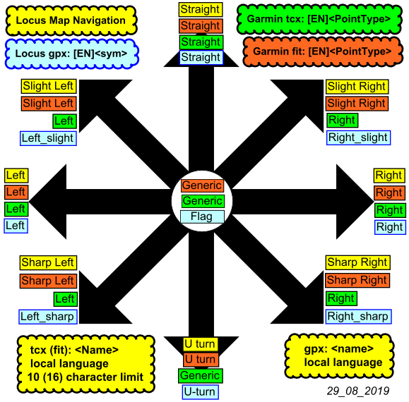
:) Turn instructions in waypoints support.
:( Limited turn range support.
:( Truncated name and cmt text.


You cannot view this attachment.

Compare Garmin tcx fit & Locus gpx.


Prefered gpx mode.
B. Instructions in trackpoints. (Since Locus V3.50.1)

:) :) :) :) :)      :) :) :) :) :)     

https://forum.locusmap.eu/index.php?topic=5953.msg49519#msg49519

:) :) :) :) :)      :) :) :) :) :)
#143
@uatschitchun. See > Advantages::)

Suggestion Idea Locus Route Planner.
Non existing function in actual Locus.

Router adds timestamps according to +/- realistic (personal) speed expectations.
Set your personal avg speed, visualised in the Locus % Slope trackcolor legend.
Personal variable speed within the % Slope zones by using the gpx <ele> data.
[Dark Blue_36kmh-Green_16kmh-Red_2kmh.


(Off bike 2kmh = non advised traject).

By the way...change or add timestamps is not critical using the trk_navtrkpt mode as the method does not need any "associated waypoint" for secure robustnavigation.

Note.
The speed specifier should not necessarily go from slow to fast.
For steep descents, the walking speed is slower than on flat terrain.

Anyway correct ETA calculations is a rather complex subject  :o
https://en.wikipedia.org/wiki/Naismith%27s_rule
#144
UPDATE ! Locus 3.50.1  Operational ! (Import)

Gpx track navigation.

Instructions in trackpoints trkpt.

Trackpoints that contain a compatible [EN]sym are promoted to navigation instruction points.
The promoted trackpoints that contain [EN]type Via are announced.
The promoted trackpoints that contain [EN]type Shaping are not announced.

Only the Turn and Via points lead to navigation alerts and give distance values @ navigation.

Advantages.

- Navigates 100% faithfull after gpx track import even without (routable) maps present in the app.
- Manage/separate the free located (poi) waypoints without any risk to damage the navigation.
- Easy import, navigate 100% faithfull without "must" set: "Merge waypoints with imported track".
- Less fragile than the trk_navwpt method with the more vulnarable associated waypoints.
- Compact POI wpt_list not cluttered by many associated wpt's as by the trk_navwpt method.
- Synced gpx files to pc offers extra edit tools or an alternative for only Locus edit.
- You can simply add multiple additional selected freely positioned wpt's(poi) into the gpx file.
- Timestamps are not obligatory but recommanded and attached according to expected speed
- A single gpx file can also contain multiple navigation tracks including turn-by-turn instructions. 
  Contains the original plus several free to select alternative navigation tracks to choose from.

The Via trackpoints by the <sym>pass_place <type>Via can have a <name>text to be announced by TTS.

@ gpx IMPORT.
Locus map app. (V3.62.1)
:) Turn instructions by trkpt <sym>(turn) & Via Points by the trkpt <sym>pass_place
:) A <sym>pass_place <type>Shaping trackpoint is considered to be a "Silent Via Point"
:) Roundabout support.
:( A <sym>turn plus <type> Shaping or Via in the same trackpoint is NOT supported.

Cruiser app. (V3.0.0)  https://wiki.openstreetmap.org/wiki/Cruiser
:) Turn instructions by trkpt <sym>(turn) & Via Points by trkpt <sym>pass_place and <type>shaping or via.
:) Shaping & Via Point transfers by point <type> in gpx (trk)track (trkpt) and (rte)route (rtept) or wpt.
:) A <sym>turn plus <type>Shaping or Via in the same track point is supported.
:) Straight line route planner support by the segment target trkpt <src>beeline and the BRouter app.
  https://groups.google.com/g/cruiser-users/c/zvjvDrntLj8/m/8KhFB8ZBCAAJ[/i]
:) Roundabout support.
   

@ gpx EXPORT.
Locus map app.
:( Export is not supported


Cruiser app. (V3.0.0)  https://wiki.openstreetmap.org/wiki/Cruiser
:) Shaping & Via Point transfers by point <type> in gpx (trk)track (trkpt) and (rte)route (rtept) or wpt.
:) Turn instructions by trkpt <sym>(turn) & Via Points by trkpt <sym>pass_place and <type>shaping or via.
:) Via and Shaping by type are 100% supported: By trkpt <type>Shaping is a non announced planner point.
:) U-turn & Shaping or Via Point at the same track point position is supported.
:) Straight line route planner support by the segment target trkpt <src>beeline and the BRouter app.
  https://groups.google.com/g/cruiser-users/c/zvjvDrntLj8/m/8KhFB8ZBCAAJ[/i] 
:) Trackpoint timestamps according to the transportation mode selection are attached.
:) Roundabout support.

#145
http://www8.garmin.com/xmlschemas/TrainingCenterDatabasev2.xsd

Garmin        <=>      Locus
tcx files.         <=>    gpx files.
Coursepoint  <=>    Waypoint (wpt)
<PointType>   <=>    <sym>
<Name>         <=>    <name>
<Notes>         <=>    <cmt>

Single Coursepoint attached to a Single trackpoint. Corresponding in Position and timestamp.
<PointType> tag (english).
<Name> tag (local language ok):  Text limit max. 10 characters.
<Notes> tag (local language ok):  Text with detailled Guiding info.

Garmin <PointType> .tcx
"Generic", "Summit", "Valley", "Water", "Food", "Danger", "Left", "Right", "Straight", "First Aid",
"4th Category", "3rd Category", "2nd Category", "1st Category", "Hors Category", "Sprint"

Locus <sym> .gpx
"Flag","Summit","Dropoff","Drinking Water", "Restaurant", "Danger Area", "Left", "Right", "Straight", "Medical Facility","Number 4, Red", "Number 3, Red", "Number 2, Red", "Number 1, Red", "Number 0, Red", "Civil"
#146
Navigation & Guidance / No .tcx file support Locus ?
September 23, 2014, 10:21:24
No .tcx file Import. Export .tcx file. Not compatible with Garmin Gps.