Menu

Show posts

This section allows you to view all posts made by this member. Note that you can only see posts made in areas you currently have access to.

Show posts Menu

Messages - Christian

#16
Servus,
ich wärme das Thema nochmal auf. Bin ebenso auf der Suche nach guten Karten mit den AV Wegnummern. (Die Wegnummern fehlen zumeist in OSM und dazu kommt noch irgendeine Einschränkung mit der Anzahl der Felder in MapsForge... schade. Wer etwas weiß, wie man das mit einem Renderthema angezeigt kriegt, bitte hier reinschrieben)
Die Kompasskarten scheinen wohl die Einzigen zu sein, wo verläßliche Wegnummer-Angaben vorhanden sind _und_ die in Locus angezeigt werden können. Dummerweise gibt es in meinem Locus keinen Eintrag von Kompasskarte unter Online-Karten. Kann das jemand verifizieren?
Hat jemand einen anderen Tip, um an Wegnummern zu kommen?
Danke ,
Christian
#17
Quote from: Menion on September 22, 2020, 22:13:16
@Christian
unfortunately I'm unable to simulate it. This happens also in track, created by the route planner, saved and then immediately edited?
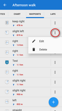
To avoid confusion: the problem belongs to waypoints in track details:

And its indepenent of route planner, time or editing.
#18
If you delete a waypoint in a track within the trackmanager the waypoint does not disappear until Locus is restarted. I reported this bug some month ago but it still exists.
#19
Servus,
da gibt es mehrere Möglichkeiten:
1: die zwei schon fertigen Tracks anzeigen lassen, dann den Routenplaner starten und den Teil dazwischen erzeugen. Im Trackmanager die drei Tracks zusammenführen.
2: die zwei schon fertigen Tracks anzeigen lassen, dann den Routenplaner starten und vom Anfangspunkt des ersten Tracks zum Endpunkt des zweiten Tracks routen lassen, ggfls nachbessern per 'via Punkte'
3. die zwei fertigen Tracks im Trackmanager aktivieren, "Tracks zusammenführen" (evtl. Reihenfolger mit den gepunkteten Schiebern verändern) und die Option "Lücken zulassen" deaktivieren und hoffen, daß dort was sinnvolles dazwischen geroutet wird. (Noch nie probiert).
Ich bevorzuge #2.
hth.
#20
Quote from: poutnikl on September 02, 2020, 22:20:58
Effective category should be more important than formal category.
eh'...
I'm out.
#21
Can't agree. Cobblestones are the archetype of paving. The advantage appears when it is wet and muddy. Have a look at the ancient romans roads.
Cobblestones are not comfortable but better then broken tires or cars sticking deep in the mud.
#22
Nice. Surfaces and way types are really important to know - before you start. (There is already a feature request ;))
I created a Excel sheet some years ago where I can fill in  the Brouter output and get a hugh amount of stats. Very helpful for route planning i.e. for the road bike: are there some gravel / unpaved sections on the way ? So if you put the Cobbelstones into the gravel category this would lead to misinterpretation. Cobbelstones belong to paving.
The other way round for MTB route planning: how much unpaved section can I expect? Cobbelstones as Gravel would be wrong.
So please be careful with the assignment.

@poutnikl: nearly all kind of stones (with the meaning of OSM syntax), even unhewn, are poured in concrete or earth or sand. Not rolling or sliding. Only Pebbelstones are like gravel.

My suggestion:
paving_stones, paving_stones:30, paving_stones:20, cobblestone, cobblestone:flattened, sett -> STONES (I would call it PAVING_STONES instead of STONES to avoid confusion)
pebblestone, gravel, fine_gravel -> GRAVEL

my2ct.
#23
Thank you. I can live with that.
#24
No. The soft buttons are activated.
#25
Quote from: tapio on May 18, 2020, 16:48:38
Quote from: Christian on May 16, 2020, 12:02:41Additional question: Is this a Android thing that the Android bottom bar disappears or is it triggered by Locus? The hidden bottom bar is the reason i have to use the Exit button. See above.
Isn't that related to fullscreen mode of Locus?
Yes, thanx. I had fullscreen mode activated since years but the Android bottom bar disappeard since a couple of weeks.
Shall I expect that the Android bottom bar should re-appear when double tap on the screen and the LM bars appear  - means, the fullscreen mode is deactivated?
#26
Additional question: Is this a Android thing that the Android bottom bar disappears or is it triggered by Locus? The hidden bottom bar is the reason i have to use the Exit button. See above.
#27
When using the button "Exit" in the right bar Locus is terminated without confirmation which is activated in expert settings (confirm on exit = enabled).
:(
#28
I took part in the poll LOL
Miss the actual design too.
Center & rotating are my most used functions (on the bottom bar). And the Route Planner (side bar).
I guess Menion is looking for a new look & feel for Platinum Eternity Edition. Looking forward to see the reason for a new functional GUI design which will be better than the actual design.
Menion can you pls. do a test: try to control the screen with dirty, sweaty gloves on the bike with your new designs... Thanx.
#29
In einem Texteditor Deiner Wahl:
<link href="www.rrrr.de"></link>
Einzufügen nach </desc> und vor <trkseg>.
Meines Wissens existieren in Locus keine extra Felder für Links. Du kannst Links in die Beschreibung ("Trackdetails") einfügen und Locus wandelt sie in klickbare Links (im fortlaufenden Text = Desc-Tag) um. Das ist aber von dieser Software abhänging. Du kannst die Links in der Beschreibung dann nicht mit "Info bearbeiten" editieren :(
Im XML Standard ist deswegen dafür der Link-Tag vorgesehen.

Edit ist überrascht, daß unter der Fantasie-Adresse doch eine Webseite steckt. War keine Absicht ;)
#30
The former thread is closed so i post it here:

Quote@Christian
I never noticed this problem, but it will be definitely a little complicated to solve. Tracks stored in Locus Map database has, among others, stored small configuration how they may be loaded into route planner. Any of this config is not exported to any format. So to be able to properly fix it, I, unfortunately, need a) exact steps to simulate it or b) full backup of your Locus Map where will be points&tracks database so I'll be able to use the same data as you.
There are no exact steps to comprehend :(
If i remember correctly the points generated during the editing are stored in an extra table in DB, right? Can i empty this table? Not via GUI - I know...