Menu

Show posts

This section allows you to view all posts made by this member. Note that you can only see posts made in areas you currently have access to.

Show posts Menu

Topics - john_percy

#1
With the latest Locus Pro classic, attempting to go to a LoPoint after a search crashes Locus and causes a restart. It was OK not so long ago!
This has also been reported by a German speaking user in the OAM forum.
#2
With some routes I have imported (around 400 track points) Locus Classic crashes when I attempt to Re-route direct from the map screen. If I attempt to Re-route from the track detail screen or track manager ît  pauses then reloads track manager, restarts Locus or reports a crash.
#3
Maps / World base map goes crazy
May 23, 2023, 20:43:29
The Locus World Base Map goes crazy on the M25 orbital motorway around London. See the two screenshots. The first is World Base Map, the second(correct) is OSM data.

Sent from my moto g(6) plus using Tapatalk

#4
Has anything changed in the Mapsforge renderer to cause place names to split as in the attached screenshot? Two of the villages have their names split. If I reduce the font size I can stop the splitting but at the expense of legibility.
It looks as if the text box width is now too small.


Sent from my moto g(6) plus using Tapatalk

#5
Troubles & Questions / Forum post enumeration weird
October 22, 2022, 01:20:40
Tapatalk seems to be having some difficulty handling topics with several hundred posts. My latest posts on Voluntary theme keep appearing at #192/202 on entering the forum. They stay at that # place on scrolling, even to the end.
However pressing the >> rearranges the posts so that those latest ones are indeed last in the list.
#6
Troubles & Questions / Tapatalk
May 04, 2022, 10:23:21
Tapatalk has gone funny.
I had to reinstall it to get it to work and now it won't log in to the Locus forum.
See screenshot for error. I can access the forum via the web interface but it really doesn't work well on a mobile.
#7
Would it be possible to have an alternative extension other than .lnk for the link to the legend for a theme? I have in mind, say, both .lnk and .link working.
Why? Currently it's a pain if you use Windows to prepare the files, as Windows assumes the file is a Windows shortcut, hides the extension and treats it accordingly.

Sent from my moto g(6) plus using Tapatalk

#8
I'm getting a failed Microsoft log in when I attempt to use the Install to Locus button from OAM maps.

Error diagnostic:
Request Id: e94c6385-75c2-4508-b1ad-e7b0d559fe02
Correlation Id: d3da7571-bbfd-422c-8a61-5e3d2489b3f2
Timestamp: 2022-02-06T00:06:25Z
Message: AADSTS900144: The request body must contain the following parameter: 'client_id'.

No idea why a Microsoft login is relevant in any case.
I've restarted my phone but the error persists.

Sent from my moto g(6) plus using Tapatalk

#9
I recently came across this website: https://www.rowmaps.com/osmand/ that provides rights of way (footpath, bridleway and byway) data that can be overlaid on maps in Locus. The page I've given gives details on how to use it with Osmand but it works similarly with Locus.
The data comes from local authorities open database and is more comprehensive than the available Mapsforge-based maps, though the mapping is less precise.
The only drawback is that there is so much data that map drawing can be very slow unless you restrict what is displayed to the nearest 50 tracks for example.


Sent from my moto g(6) plus using Tapatalk
#10
Troubles & Questions / Online map cache timeout
April 22, 2021, 11:14:35
How do I set cache timeout to "never" (or "valid for" to forever)?
Do I set the value in the field to 0, -1, or a very large number?
I can't find anything in the knowledge base.


Sent from my moto g(6) plus using Tapatalk

#11
Maps / Usage = cyclo not English
December 31, 2020, 18:12:36
Map usage categories use the word "cyclo" which is not English. How about "cycle" instead?


Sent from my moto g(6) plus using Tapatalk

#12
Other features / World map at low zooms
December 24, 2020, 12:15:09
If I remember correctly, world map at low zooms used to be an option for vector (offline) maps only. Now it applies to all maps.
I want to be able to display overlays such as weather at low zooms. To do this currently I have to turn off the world map display for all types of map.
Ideally I would like to turn on or off the world map display for vector maps, raster maps and overlays separately - and even be able to set the zoom at which it switches. Maybe that's asking too much and I would be more than happy to just allow overlays to appear over the world map.


Sent from my moto g(6) plus using Tapatalk

#13
Other features / Hill shading intensity
April 30, 2019, 11:12:15
It seems to me that the hill shading gets increasingly intense at lower zoom levels to the point where it can easily obscure important map details in hilly terrain.
I have two requests
1. Please turn down the volume control at lower zoom levels so the hill shading is more visually consistent
2. Please introduce an intensity control for hill shading in settings


Sent from my moto g(6) plus using Tapatalk

#14
I use the Locus World base map from the Locus Store for improved speed at low zooms when using vector maps. I note it does not switch in if I am using a Mapsforge v4 map.  :(
#15
3.33 Locus Free "Navigate to" crashes. Both with Brouter offline and Graphhopper online engines. Both via popup on point and button in side menu.
Perfectly ok in Pro version.

Sent from my XT1039 using Tapatalk

#16
Troubles & Questions / Map cache "valid for"
April 28, 2018, 18:26:10
I am attempting to use an overlay to display traffic delays and road closures and I can't get it to display reliably..

I have some questions regarding the time validity of the map cache.
1. If I "Set valid for" to 0, does that mean the map is not cached, or that the cache does not expire?
2. Does the same validity apply when the map is used as an overlay rather than a base map?
3. Regardless of the expiry time, is the map cached anyway within the same session of Locus. That is, is the validity of the cached copy only tested when Locus is restarted? To put it a different way, once the map is accessed once in a session, is the same image used until Locus is closed?

Much the same questions apply if I attempt to use an online map with traffic conditions.
#17
Other features / Inconsistent user interface
April 26, 2018, 12:04:39
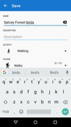
I think it is time for some consistency in the user interface, particularly with regard to accepting or cancelling settings screens. I illustrate three different screens in particular.

1. Changing info text for a track.

Do I tap the back arrow, or the SAVE text? Answer, no. Hide the keyboard and there's a SAVE button underneath.

2. Choosing available maps.

Does the X on the top right corner cancel? No, it accepts the settings in the check boxes.

3. Accepting terms of use for a map

No, the orange box is not a confirmation button. That's up in the top corner, where it says CONFIRM. And the X means cancel this time.

Oh Menion, let's get this right!
#18
Themes - Vector maps / [Theme] OS Style
February 26, 2018, 16:34:35
Just for fun, I've produced a theme that mimics the UK Ordnance Survey styles as far as possible. It's available for free download here.
|
left: Actual Ordnance Survey
right: OS-Style theme

Updated 9 March 2018
Corrected 11 March 2018
#19
Troubles & Questions / Backup and restore worked
December 27, 2017, 15:47:07
For some reason Locus Pro disappeared from my phone today. Just went.
I reinstalled from the Play Store but all my settings were gone. So, I found the latest automatic backup and did a restore and now all is well!

Sent from my XT1039 using Tapatalk

#20
Troubles & Questions / POI grouping
September 27, 2017, 10:26:06
Either I don't understand the Group POI switch in Settings, or it is not working properly.
Looking at an area where there are many POIs, such as central London, I get numbers in circles corresponding to multiple POIs whether I turn the switch on or off.
I am testing with the internal Hike & Bike theme. In the third image below I have circled the markers for multiple POIs

| |
"Group POIs" switch | Screenshot | Screenshot with POI groupings circled