Menu

Show posts

This section allows you to view all posts made by this member. Note that you can only see posts made in areas you currently have access to.

Show posts Menu

Messages - ThomasD.

#1
Track recording causes no problems. My test setup used an active navigation with many recalculations (maybe 30+ during a 45 min ride). So I believe it will be connected. Anyway, I promise I'll look at it during the next weeks ...
The following users thanked this post: ThomasD.
#2
We tend to overengineer things. IMHO the previous workflow was perfectly fine as it was also covering the use case which I guess was used the most:

- Navigate: from GPS position to point X
- Plan route: do it in detail the way you like/need

but that just my opinion and the way I use LM.
The following users thanked this post: ThomasD.
#3
Hello Thomas,
thanks for the shared backup. For unknown reasons, in the database exists two points that do not belong to any group. How this may happen > I have no idea. Anyway, it was solvable so it is improved in the new Beta version. If you have a moment, give it please a try, thanks.
The following users thanked this post: ThomasD.
#4
Hello Thomas,
sorry to see this. You may create an error log, but I'm worried it won't by clear by this failure. So I have to ask if you will be willing to share a full backup of Locus Map (made by app settings > Backup & filesystem > Backup manager > manual backup) with me. So I should be able to simulate this issue on my own device.

I guarantee that data remains save and private and will be deleted once the issue is fixed. You may share it over any cloud service here on the forum over PM or over locus.map@asamm.com support email. Thanks a lot!
The following users thanked this post: ThomasD.
#5
Ihr habt mich dazu bewegt, mal wieder in die Übersetzung (LM4) zu schauen. Ich mache da nicht viel, da ich Locus auf Englisch betreibe. Ich habe ein paar Dinge geändert. Diese Stellschraube reicht aber nicht aus, was die größeren Verständnisprobleme angeht. Aber es hilft etwas.

Allerdings ist da eine Sache. "Preset" vs. "Voreinstellung" vs. "Vorgabe" - Es wird in der derzeitigen Übersetzung alles genutzt. :( Das ist nicht gut.
Ich meine: hier kann man ausnahmsweise Denglish nehmen - "Preset" - wir sollten an der englischen Terminologie bleiben, da man sonst alles durcheinanderwirft und es auch im Support zu Problemen kommt. Ich habe ehrlich gesagt jetzt radikal die restlichen "Voreinstellungen" durch "Presets" ersetzt, wo diese auch gemeint sind. Das kann durchaus zu Protest führen. Kann man ja auch wieder ändern.
Wie seht Ihr das?

V=Vorher, N=Nachher

V: "Das neue Preset enthält aktuelle Einstellungen. Änderungen am Preset sind nach der Erstellung möglich."
N: "Das neue Preset übernimmt aktuelle Einstellungen. Änderungen am Preset sind nach dessen Erstellung möglich."

V: "Wähle Einstellungen, die durch diese Vorgabe geändert werden"
N: "Wähle Einstellungen, die durch dieses Preset geändert werden"

V: "Mit Voreinstellung verknüpfen"
N: "Mit Preset verknüpfen"

V: "Gewählte Voreinstellung automatisch bei Navigationsstart aktivieren"
N: "Gewähltes Preset automatisch bei Navigationsstart anwenden"

Das letzte Beispiel, "anwenden" statt "aktivieren", ist zum Beispiel wichtig bzgl. des Verständnis. "Aktivieren" impliziert, man könne da wieder etwas deaktivieren/ausschalten. So funktionieren Presets aber eben nicht. Sie überschreiben einfach nur stumpf Einstellungen.
The following users thanked this post: ThomasD.
#6
I have uploaded a new version in the first post in this thread.
Changes are numerous:
- Added wintersports with skiing pistes (downhill and Nordic) and sledding, with difficulty shown, as selectable option in Hiking and Wintersports style.
- Protected areas now shown as gold (access allowed) or pink (access restricted) tint  which is most intense at low zooms and becomes fainter and less distracting as you zoom in.
- Surface for cyclable ways now shown, when cycle tracks and lanes, or Cycling style is selected
- Hiking, cycle and MTB routes can now be displayed independently of paths and tracks
- Improved display of hiking, cycle and MTB routes
- Also added: cutting, hedge, row of trees, water park area (corrected), beach resort, cliff diving, free flying (kite surfing etc), climbing adventure (Go Ape etc), roller skating, skateboard, miniature golf, ice cream vendor, emergency access point, historic stone, memorial stone, boundary stone, natural stone, log barrier, ditch barrier, natural earth bank, block barrier, town hall, art work, water works, sewage works, covered parking, private playgrounds; historic buildings, military buildings distinguished; historic areas shown.
- Icons changed for kissing gates, stile, pharmacy, doctors, toilets, recycling (colour change), playground, emergency phone
- Adjusted zoom levels for roads for consistency
- Updated key: https://bit.ly/VoluntaryKey
The following users thanked this post: ThomasD.
#7
Themes - Vector maps / Re: [Theme] Voluntary UK
March 07, 2020, 15:12:15
Minor bugfix for Locus version in the first post.
The following users thanked this post: ThomasD.
#8
To all users of Locus and Openandromaps,

I have just published some major updates for my themes "outdoor" and "desert" and added the new theme "navigation". You can find some description (in German) and the downloads also on:

www.maiwolf.de/locus/
Please use always my website to download the NEWEST version of the theme!

Here a brief summary of changes:
- the 3 themes use a common backbone, meaning in general they use the same styling and symbols
- they differ in zoom levels, detail levels and amount of selectable features
- they can be used in parallel on the same device
- all symbols (nearly) are now switched to svg (scalable vector graphics)
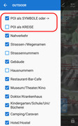
- the most predominant symbols can be switched to be only small circles to not overpopulate and confuse the map
- the "navigation" theme is thought to be used for car navigation and shows road bigger but leaves off some other elements (i. e. elevelation lines)

Feel free to use them and send me feedback.
I am constantly trying to improve these themes.

Regards

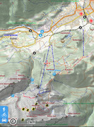
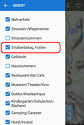
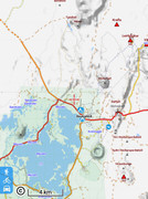
Here are some screenshots and the themes for download.

Theme icons which show up in Locus:


The "outdoor" theme:


The "desert" theme:


The "navigation" theme:


The following users thanked this post: ThomasD.
#9
Themes - Vector maps / Re: [Theme] Voluntary UK
February 26, 2018, 16:56:00
Multilingual (Mapsforge v4) maps from OpenAndroMaps can now be displayed with the included Voluntary Mapsforge theme, which is only offered as an option when a Mapsforge v4 map has been selected. Voluntary Mapsforge is as similar to Voluntary UK as possible.
Other changes:
- Addition of switchable tracks in City and Roads styles
- "Blue" icons darkened to improve visibility
- Buildings under construction shown in latest OAMmaps
- Cable cars now hang downwards in Voluntary Mapsforge and Cruiser/Orux version
- Velocity colours revised (track/residential/runway/military etc)
- Voluntary UK national/international cycle routes set to red labels (as UK signage)
- Rendering order and style of roads under construction changed
- Alignment of passes; abandoned and active mine and military bunker now shown on OAMaps.
- Peaks appear at zoom levels according to their local prominence on OAMaps.
- Bridges align for cycle tracks on OAMaps.
- Race track bridges, tunnels shown.
- Paths etc slimmed slightly

Latest version in first post in this thread.
The following users thanked this post: ThomasD.
#10
So, es geht. Ich habe mir mal die config.cfg angeschaut und siehe da, man muss den folgenden Eintrag auf 0 setzen (voreingestellt ist 1) und schon bleibt man von der Meldung verschont:

# Notify if GPS is disabled in system during start of Locus (default: true)
gps_notify_if_disabled_during_start=0
The following users thanked this post: ThomasD.
#11
Themes - Vector maps / [Theme] Voluntary
March 04, 2013, 18:22:01
Theme last updated 22 January 2024. Download and install from https://voluntary.nichesite.org

The Voluntary themes support OAM maps and both new and old LoMaps.


The Voluntary theme is designed for clarity of display. Its colours are based on UK Ordnance Survey conventions and will be fairly familiar to British users. Even if you are not British, the colours and styles will probably work well for you. It automatically scales for devices with displays of different resolutions and symbols enlarge smoothly for higher zoom levels. The zoom levels at which various features appear has been adjusted to provide optimal information and reduce unwanted clutter.


You can choose Hiking, Cycle, City, Multi, Yellow or Transparent style when you select the Voluntary UK theme.

The styles take advantage of switchable options. Display of hiking, cycle and mountain bike routes can now be switched on or off, as can highlighting for each of them. The number of options shown is relatively limited to aid ease of use. Cycling, Hiking, City and Road styles function almost as presets with a limited range of tailored options. Within these particular styles the display is subtly tailored to its purpose: for example, Road displays junction and road numbers better; Cycling has a better display of cycle routes. Multi, Transparent and Yellow have a fuller (but manageable) range of options. Locus remembers the settings of the options for each style.

The City style is aimed at use in large cities such as London and has a less cluttered (and slightly faster) display at low zoom levels. Colours in the Yellow theme are more muted and are aimed at use with overlays.

A "Transparent" style turns off the map background and enables use of a vector map as an overlay on top of a satellite image in Locus. Similarly the "background" checkbox in the Yellow style can be used to achieve the same effect.

Generally, blue dashes are cycle ways, green dashes represent dual use both on bike and on foot (bridle paths in the UK), and brown shorter dashes use on foot only. Blue blobs are cycle routes, green blobs are hiking routes. Mountainbike trails are shown by violet blobs. Cycle routes are also indicated by blue dashes on the roads. Hiking, cycle and mountainbike routes can be emphasised by selectable overlays.

The theme is designed to work well with both LoMaps from Locus Store and maps from OpenAndroMaps. Footpaths, bridleways and cycleways are indicated on the map by dashed lines where they follow the path of a mapped track or pedestrian way if the map supports it. On maps from OpenAndroMaps, blue dashes on roads are either cycle routes or roads with cycle tracks alongside, while shorter blue dashes on roads show cycle lanes in the road.

The Locus package includes two flavours: one that works with older LoMaps (LE) and one that works with the newer LoMaps as well as Mapsforge maps, such as from OpenAndroMaps (V5 LE). The appropriate theme appears according to the map selected.


Also included is the visually-similar Velocity theme for a simpler display with much faster drawing.   

The package is also available in  versions for other apps such as Cruiser, Orux Maps, etc.

o V5 for latest versions of Cruiser, Orux etc
o V5- for apps that cannot display text on curved paths
o V4 for apps that cannot scale dotted and dashed lines.

Voluntary and Velocity themes can be downloaded and installed from https://voluntary.nichesite.org

The following users thanked this post: ThomasD.